
Pricing Change
New pricing for orders of material from this site will come into place shortly. Charges for supply of digital images, digitisation on demand, prints and licensing will be altered.
Bute, Balnakailly Bay


Air Raid Shelter (Second World War), Decoy Site (Second World War), Graffiti (20th Century) - (21st Century)
Site Name Bute, Balnakailly Bay
Classification Air Raid Shelter (Second World War), Decoy Site (Second World War), Graffiti (20th Century) - (21st Century)
Alternative Name(s) Corranach Knowe; Balnakailly; Rhobodach
Canmore ID 305084
Site Number NS07SW 88
NGR NS 01778 74466
NGR Description Centred
Datum OSGB36 - NGR
Permalink http://canmore.org.uk/site/305084


- Council Argyll And Bute
- Parish North Bute
- Former Region Strathclyde
- Former District Argyll And Bute
- Former County Buteshire
NS07SW 88 02976 72876
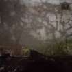
A concrete building, now situated within commercial forestry but visible on current OS mapping, may have formed part of a dummy village during the Second World War (Sandeman 2006).
Information from RCAHMS (GFG) 3 September 2009.
Reference (2006)
Field Visit (26 September 2019)
What remains of this Navy Series decoy, is situated at the NE end of Bute. It originally extended a distance of about 1.8km (1 mile) from WNW to ESE by 0.55km (⅓ mile) transversely, covering an area of 64.5ha (160 acres) - excluding Eilean Mor (NS 01823 74951), Eilean Fraoich (NS 01620 75153) and the surrounding rocks in Balnakailly Bay, which also lay within its bounds. This large tract of ground extended along the coast from the golf links at Rubha A’ Bhodaich (NS07SW 95) (NS 02675 74276) to Buttock Point (NS 01059 74991) and the Maids of Bute (NS 00819 74573), encompassing the NE slopes of Buttock Hill and the broken country to its ESE (NS 02333 73895 to NS 02365 74014 to NS 0237674081). It is now blanketed with coniferous plantations, deciduous woodland, scrub and some improved pasture on the links. The decoy would seem to have been under the management of two control shelters, which may well have split their roles. That at Corranach Knowe (NS 02976 72876) may have had responsibility for the lighting effects mimicking ships’ lights, goods yard lights, signal lights, skylights, eaves lighting, louvre lighting, open doors and dirty windows, while that at Bainakailly (NS 01560 74106) may have had responsibility for the cordite fire flashes, baskets fires, boiling fires, grid fires and drip fires. All of these elements played their part in the plan, which was to replicate the S coast of the Clyde between Gourock and Greenock at night.
Apart from the two control centres little of the decoy's infrastructure can now be located. There is at least one concrete platform, a small mound, a tangle of cabling just below the ground surface which originally connected the lighting installations and four metal tanks for the boiling fires. There is also a substantial air raid shelter at Rhobodach farm, where the crews that staffed the decoy were accommodated and which was provided for their use in emergencies.
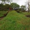
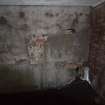
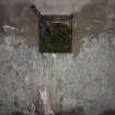
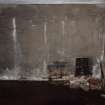
The control shelter on Corranach Knowe (NS 02976 72876) is situated in a dense coniferous plantation about 850m SSE of Rhobodach, where it has been partly dug into a NE-facing slope. It is rectangular on plan and measures 10.8m from NE to SW by 4.2m transversely over brick walls 0.35m thick and about 2.15m high. It is encased in a grass-grown earthen blast wall up to 3.4m thick, which originally enveloped the whole building, including the flat reinforced concrete roof. A raised escape hatch retaining an iron flange for the missing trap door is centred at its NW end. The entrance, which is only protected by wing walls built to retain the earthen constituents of the blast wall, is situated centrally on the SW. Three steps lead down to a doorway below a canopy which provides access to a flooded lobby measuring 3.35m from NE to SW by 2.3m transversely and at least 1.93m high. Its walls are rendered with plaster and centrally placed doorways retaining their wooden frames oppose one another on the NW and SE. A horizontal channel that once conveyed electrical cabling runs across the NE wall between the compartments to each side of the lobby. The flooded control room to the NW measures 3.65m from NW to SE by 3.36m transversely. Its plastered walls and ceiling retain traces of whitewash. However, this render is broken where switchboards and junction boxes have been removed. Six steel rungs attached to the NW wall permit egress from the escape hatch and there is a downpipe close to the NW corner, which may have been part of the chimney for a stove. Single rectangular vents fitted with an iron grill are positioned just above floor level close to the NW and NE corners, while the apertures of three pipes clustered at the SE corner are probably conduits for cables. The door to the generator room on the SE side of the lobby also retains its wooden frame. This compartment, which is flooded like the rest of the interior, measures 3.35m square. The ceiling and walls have also been whitewashed and traces of a switchboard are visible in the damaged plaster immediately NE of the door, while rectangular vents just above floor level close to the NE and SW corners are attached to ceramic pipes on the exterior, which lead through the blast wall. Unusually, there are no concrete plinths for the engines on the floor, but a pipe supported on a brick pier, emerges from the centre of the SE wall to run for just over a meter about 0.3m above the floor. In the wall directly above and just below the ceiling is a large circular vent, which conducted the exhaust gasses outside. The large U-shaped ceramic pipe that helped expel these gasses through the blast wall, still attached to the external brickwork, is a very rare survivor. There is no trace of a heat exchanger to its SE.
The Balnakailly control shelter (NS 01560 74106) is situated about 1.85km NW of Corranach Knowe and 700m S of Bear Craig. It is partly dug into a steep N-facing slope in open scrubland at the edge of mixed woodland and has a fine outlook over the Kyles of Bute and Loch Ruel. It is exactly the same design as that on Corranach Knowe but differs in being orientated from WNW to ESE and approached from the SSW by a flight of nine steps that lead down to a metal threshold at the entrance. Some minor modifications appear to have been introduced with use; but this shelter preserves evidence for the lobby and the compartments having been illuminated by electric lights at the centre of the ceiling, the stove having been sited at the SW corner of the control room and for at least one generator being stabilised by eight retaining bolts set in the concrete floor. In addition, immediately W of the shelter and under some trees are the largely buried remains of the heat exchanger.
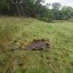
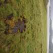
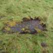
Little survives of the installations that made up the decoy. A turf-covered concrete platform (NS 02303 74193), measuring 1.1m from N to S by 0.74m transversely and at least 0.1m high, is situated in improved pasture on a terrace overlooking Balnakailly Bay, while a bracken- and grass-grown mound (NS 01527 74478) measuring 6.2m from N to S by 2.6m transversely and 0.45m high, is located in waterlogged ground in birch and alder scrub 290m S of Bear Craig. A tangle of cabling (NS 02664 74272) was noted in an excavation close to the gateway leading to the links about 65m NW of the pier for the Colintraive ferry - confirming local testimony that such cabling is ubiquitous in the fields around Rhobodach. However, the rusting remains of four sheet-metal oil tanks (NS 01065 74855), situated on a gentle E-facing slope in deep bracken and rushes 130m S of Buttock Point, are a very rare survival. All have been moved from their original positions, but a plan (ADM199/733) dating to 1941 and an aerial photograph (CPE/Scot/UK/0325 3287) flown on 26 March 1948 indicate that they were collected together from close-by, presumably in anticipation of their removal as scrap. Two measure 1.22m square and 1.53m deep and are strengthened at the top by a welded iron cross-strap. They have a small circular aperture at the base and an overflow pipe just below the top. Another measures 1.22m cubed and has a welded cross strap at its mid-point, while the fourth tank has entirely collapsed. A short length of iron piping attached to a bracket (NS 01698 74538), lying in the bracken 700m SW of the tanks, almost certainly formed part of the system that distributed the oil to the network of fire appliances.
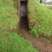
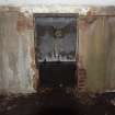
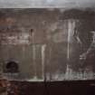
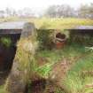
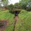
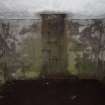
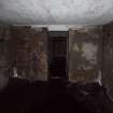
The air raid shelter (NS 02752 73731) for the decoy crews at Rhobodach is situated in the garden about 45m NW of the house, where it is terraced into a NE-facing slope. It is rectangular on plan and measures 5.95m from NW to SE by 3.03m transversely within brick walls 0.38m thick and 2.18m high. It is encased in a grass-grown earthen blast wall up to 4m thick, which originally enveloped the whole building, including the flat reinforced cast concrete roof. A small glazed gabled canopy covering the raised escape hatch is located at its NW corner. The original entrance is situated at the SE corner where brick wing walls retaining the blast wall define a passage leading to a doorway, the wooden frame of which is now missing. This led into a narrow, whitewashed corridor that provides access to the internal compartment at the SW corner of the structure. The walls and ceiling of the internal compartment have also been whitewashed, but the only original fittings are six staggered iron rungs on the wall at the NW corner, which permitted egress from the escape hatch. There is also a small rectangular aperture at floor level in the SE corner. This leads out into the corridor and may have been provided for electrical cabling. After the war the shelter was converted into a store by digging a way through the centre of the blast wall on the NE and hacking a wider entrance through the brickwork. Chases in the brickwork suggest it was once fitted with a door in a wooden frame, but this is now missing.
The full extent of the decoy, together with the details of the installations and their location, are shown on a series of maps drawn up in 1941 by the Civil Engineer-In-Chief’s Department at the Admiralty in Glasgow, which are held at the National Archives at Kew (ADM199/733). While one simply shows the extent of the decoy, another at a larger scale compares this part of the island’s coastline with the S bank of the River Clyde between Gourock and Greenock, which the decoy was intended to mimic. A third shows the coastline from Gourock to Port Glasgow in more detail, while a fourth meticulously denotes the character of all the decoy’s various installations, although it is possible that these have not been drawn strictly to scale. Some can be seen on RAF aerial photographs (106G/Scot/UK/0160 4471 and CPE/Scot/UK/ 0325 3286-7, 3350), flown on 21 August 1946 and 26 March 1948 respectively. However, these images indicate that what was laid out on the ground generally differed from what had been originally planned in 1941. In addition, there is a rather crude, undated map depicting the decoys protecting Greater Glasgow, which shows the coastal strip of the Bute decoy extending from a point W of Bear Craig (NS 01380 74702) to Dougal’s Rock (NS 03549 73053) in the SE. While this is not an accurate representation of its N limits, it is possible that the network of lights extended at least this far S, as the Corranach Knowe shelter would have originally had a clear view of this part of the coast. Finally, a military edition of the Ordnance Survey Ten Mile Map of Great Britain (Air20/8543) annotated ‘Defence Measures Map’, dated 16 January 1946, shows the two parts of the site as separate ‘Starfish’ in their correct relationship, but on the W coast of the island to either side of Etterick Bay (NS 03264 65654).
Visited by HES, Survey and Recording (ATW, AKK), 26 September 2019.
Measured Survey (26 September 2019)
HES surveyed Rhobodach air raid shelter on 26 September 2019, collecting GPS linework and a producing a measured sketch. The GPS linework, sketch plan and photographs were used to create a plan and section in vector graphics software at a scale of 1:100.

