
Bute, Ardnahoe


Grave Marker (Medieval)
Site Name Bute, Ardnahoe
Classification Grave Marker (Medieval)
Alternative Name(s) 'Hogback'
Canmore ID 305066
Site Number NS05NE 134
NGR NS 06790 57627
Datum OSGB36 - NGR
Permalink http://canmore.org.uk/site/305066

!['Hog back' grave stone 11th - 12th century found on the shore at Ardnhoe [sp]. It is now fixed in the wall at Ardnahoe farm. An image from the Buteshire Natural History Society archaeology photograph album, held at Bute Museum.](http://i.rcahms.gov.uk/canmore/l/SC01230812.jpg)

!['Hog back' grave stone 11th - 12th century found on the shore at Ardnhoe [sp]. It is now fixed in the wall at Ardnahoe farm. An image from the Buteshire Natural History Society archaeology photograph album, held at Bute Museum.](http://i.rcahms.gov.uk/canmore/s/SC01230812.jpg)
- Council Argyll And Bute
- Parish Kingarth
- Former Region Strathclyde
- Former District Argyll And Bute
- Former County Buteshire
NS05NE 134 06790 57627
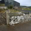
A coped grave stone, similar to the example at St Blane's (NS05SE 5.25), was discovered by D N Marshall built into a stone dyke near the shore at Ardnahoe. It was later built into the garden wall of the farmstead (at NS 0679 5764). Marshall's photographs and notes are held at Bute Museum, Rothesay.
Information from RCAHMS (GFG) 19 April 2010.
The location of this grave marker was confirmed.
Visited by RCAHMS (GFG) 1 October 2010.
Note (28 May 1943)
Miss Marshall of Stewarthall produced a photograph of a stone of triangular section, measuring apparently 6 ft in length and 12 in or more in height, which is now understood to be serving as the coping of a farmyard wall at Ardnahoe. The farmer is reported to have found it on or near the shore. It should be investigated when the Inventory is made.
Information from RCAHMS (AG) 28 May 1943
Field Visit (1 October 2010)
The location of this grave marker was confirmed.
Visited by RCAHMS (GFG) 1 October 2010.

