
Bute, Barone Park Water Cut


Aqueduct (19th Century), Bridge(S) (19th Century), Water Channel (19th Century)
Site Name Bute, Barone Park Water Cut
Classification Aqueduct (19th Century), Bridge(S) (19th Century), Water Channel (19th Century)
Alternative Name(s) Robert Thom's Water Cuts; Lover's Walk Aqueduct
Canmore ID 304552
Site Number NS06SE 424
NGR NS 0798 6379
NGR Description Mid-point
Datum OSGB36 - NGR
Permalink http://canmore.org.uk/site/304552


- Council Argyll And Bute
- Parish Rothesay
- Former Region Strathclyde
- Former District Argyll And Bute
- Former County Buteshire
NS06SE 424 0798 6379.
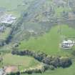
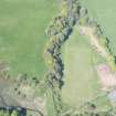
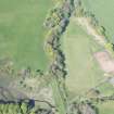
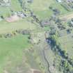
This channel, partly artificial and partly a canalised natural water course, picks up the waters of two un-named burns at NS 0763 6455 and carries them, and one other, to the Kirk Dam reservoir at NS 0835 6370, 800m to the ESE. It formed part of the water cuts created by Robert Thom in the early 19th century to increase water power to the Rothesay Cotton Mill (NS06SE 5). There were five over bridges on the cut, two of which have been removed (Maclagan 1996, 4-6).
Information from RCAHMS (GFG) 20 May 2010.
Desk Based Assessment (20 May 2010)
This channel, partly artificial and partly a canalised natural water course, picks up the waters of two un-named burns at NS 0763 6455 and carries them, and one other, to the Kirk Dam reservoir at NS 0835 6370, 800m to the ESE. It formed part of the water cuts created by Robert Thom in the early 19th century to increase water power to the Rothesay Cotton Mill (NS06SE 5). There were five over bridges on the cut, two of which have been removed (Maclagan 1996, 4-6).
Information from RCAHMS (GFG) 20 May 2010.

