
Bute, St Blane's, Chapel


Chapel (Period Unassigned)(Possible)
Site Name Bute, St Blane's, Chapel
Classification Chapel (Period Unassigned)(Possible)
Alternative Name(s) The Nunnery, Lower Churchyard
Canmore ID 303299
Site Number NS05SE 5.27
NGR NS 09484 53414
Datum OSGB36 - NGR
Permalink http://canmore.org.uk/site/303299


- Council Argyll And Bute
- Parish Kingarth
- Former Region Strathclyde
- Former District Argyll And Bute
- Former County Buteshire
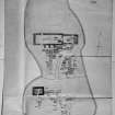
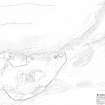
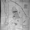
Measured Survey (1896)
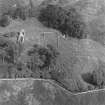
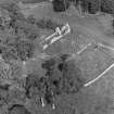
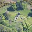
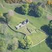
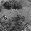
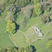
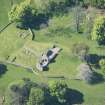
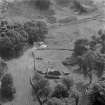
Aerial Photography (1970)
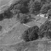
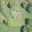
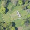
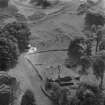
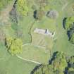
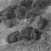
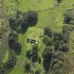
Oblique aerial photographs of the remains of St Blane's Church and burial ground, Bute, taken by John Dewar in 1970.
Watching Brief (1997)
NS 094 534 A watching brief was undertaken by Kirkdale Archaeology during masonry works on a small Early Christian chapel situated 25m to the SW of the main chapel of St Blane's. The walls and general area were photographed, and plans were made. No finds were removed from the site.
A fuller report has been lodged with the NMRS.
Sponsor: Historic Scotland
G Ewart and D Stewart 1997
Field Visit (31 March 2010)
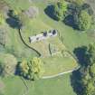
This rectangular building, probably a chapel, is situated in the lower churchyard at St Blane’s, about 30m SSW of the church (NS05SE 5.00). It measures 6.8m from ENE to WSW by 5.4m transversely over stone walls 1m in thickness and up to 1m in height at the internal SE corner, and there is an entrance, 0.8m wide, in the SSE side. The interior contains at least seven grass-grown medieval grave-slabs, one of which is decorated (NS05SE 5.3).
The chapel is depicted on the 1st edition of the OS 25-inch map (Buteshire 1869, Sheet CCXXVII.3) and annotated ‘The Nunnery’ on this and subsequent editions of the map (1897; 1924), possibly an allusion to the tradition that the lower graveyard was once used as a burial place for women (Name Book No.4, p.64; Ross 1880, 73; Hewison 1893, 189).
Visited by RCAHMS (GFG) 31 March 2010.
Watching Brief (17 March 2015)
NS 0947 5343 A watching brief was undertaken on 17 March 2015 during the excavation of a shallow trench to hold the footings for a new bench, located to the SW of the upper graveyard boundary wall of St Blane’s Church. The results of the excavation reflect the backfill or dumping of excavated/disturbed soils and rubble. The presence of six inch nails may indicate this ‘fill’ was the result of an earlier (20th century) shallow archaeological excavation in the area.
The abundance of slate fragments probably either reflect roofing material from the various medieval buildings in the area, or the extensive use of slate ‘pinners’ within the (much restored) upper graveyard boundary wall.
Archive: National Record of the Historic Environment (NRHE) intended
Funder: Historic Scotland
Gordon Ewart - Kirkdale Archaeology
(Source: DES, Volume 16)

