
Pricing Change
New pricing for orders of material from this site will come into place shortly. Charges for supply of digital images, digitisation on demand, prints and licensing will be altered.
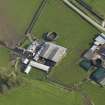
Bute, East St Colmac


Farmstead (Period Unassigned), Horse Engine
Site Name Bute, East St Colmac
Classification Farmstead (Period Unassigned), Horse Engine
Canmore ID 303062
Site Number NS06NW 110
NGR NS 04591 67308
Datum OSGB36 - NGR
Permalink http://canmore.org.uk/site/303062


- Council Argyll And Bute
- Parish North Bute
- Former Region Strathclyde
- Former District Argyll And Bute
- Former County Buteshire
NS06NW 110 04591 67308.
East St Colmac is a working farmsteading comprising a mixture of 19th century buildings and large sheds of more recent date, which is depicted in Mackinlay's map of North Bute (1823) and in more detail on the 1st edition of the OS 25-inch map (Argyllshire and Buteshire 1869, CXCIII.16). At that time it contained buildings ranged around three sides of a courtyard that was open to the SE. A horse-engine is shown adjacent to the N corner.
Information from RCAHMS (GFG) 15 January 2010.
Reference (1951)
Desk Based Assessment (15 January 2010)
East St Colmac is a working farmsteading comprising a mixture of 19th century buildings and large sheds of more recent date, which is depicted in Mackinlay's map of North Bute (1823) and in more detail on the 1st edition of the OS 25-inch map (Argyllshire and Buteshire 1869, CXCIII.16). At that time it contained buildings ranged around three sides of a courtyard that was open to the SE. A horse-engine is shown adjacent to the N corner.
Information from RCAHMS (GFG) 15 January 2010.

