
Scheduled Maintenance
Please be advised that this website will undergo scheduled maintenance on the following dates: •
Tuesday 3rd December 11:00-15:00
During these times, some services may be temporarily unavailable. We apologise for any inconvenience this may cause.
Bute, Mid St Colmac


Farmstead (Period Unassigned)
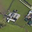
Site Name Bute, Mid St Colmac
Classification Farmstead (Period Unassigned)
Alternative Name(s) South St Colmac
Canmore ID 303061
Site Number NS06NW 108
NGR NS 04495 67184
Datum OSGB36 - NGR
Permalink http://canmore.org.uk/site/303061


- Council Argyll And Bute
- Parish North Bute
- Former Region Strathclyde
- Former District Argyll And Bute
- Former County Buteshire
NS06NW 108 04495 67184.
Mid St Colmac is a working farmsteading that contains a mixture of 19th and 20th century buildings, none of which have been recorded in detail. A farmstead is depicted here on Mackinlay's map of North Bute (1823) and in more detail on the 1st edition of the OS 25-inch map (Argyllshire and Buteshire 1869, Sheet CXCIII.16), at which time it was known as 'South St Colmac'. The 19th century steading was based around a courtyard that was open to the SE and had a farmhouse incorporated into its NW side. Ancillary buildings stood immediately to the SW and NE.
Information from RCAHMS (GFG) 15 January 2010.
Antiquarian Mapping (1823)
Field Visit (1864)
Reference (1951)
Desk Based Assessment (15 January 2010)
Mid St Colmac is a working farmsteading that contains a mixture of 19th and 20th century buildings, none of which have been recorded in detail. A farmstead is depicted here on Mackinlay's map of North Bute (1823) and in more detail on the 1st edition of the OS 25-inch map (Argyllshire and Buteshire 1869, Sheet CXCIII.16), at which time it was known as 'South St Colmac'. The 19th century steading was based around a courtyard that was open to the SE and had a farmhouse incorporated into its NW side. Ancillary buildings stood immediately to the SW and NE.
Information from RCAHMS (GFG) 15 January 2010.

