
Following the launch of trove.scot in February 2025 we are now planning the retiral of some of our webservices. Canmore will be switched off on 24th June 2025. Information about the closure can be found on the HES website: Retiral of HES web services | Historic Environment Scotland
Tiree, Carnan Mor, Radar Station


Radar Station (20th Century)
Site Name Tiree, Carnan Mor, Radar Station
Classification Radar Station (20th Century)
Canmore ID 302026
Site Number NL94SE 59
NGR NL 96830 40149
Datum OSGB36 - NGR
Permalink http://canmore.org.uk/site/302026


- Council Argyll And Bute
- Parish Tiree
- Former Region Strathclyde
- Former District Argyll And Bute
- Former County Argyll
NL94SE 59 96830 40149
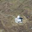
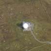
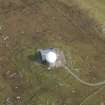
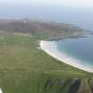
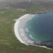
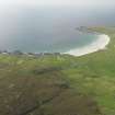
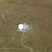
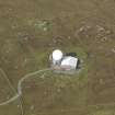
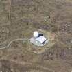
Late 20th century radar station situated at the summit of Carnan Mor. The radar site is set within an enclosure and consists of a single storey building with a small radome on the SW side.
Information from RCAHMS (DE), January 2010

