Pricing Change
New pricing for orders of material from this site will come into place shortly. Charges for supply of digital images, digitisation on demand, prints and licensing will be altered.
Bute, St Blane's
Grave Marker (Early Medieval)
Site Name Bute, St Blane's
Classification Grave Marker (Early Medieval)
Alternative Name(s) Carved Stone 22
Canmore ID 302008
Site Number NS05SE 5.22
NGR NS 09498 53414
Datum OSGB36 - NGR
Permalink http://canmore.org.uk/site/302008
- Council Argyll And Bute
- Parish Kingarth
- Former Region Strathclyde
- Former District Argyll And Bute
- Former County Buteshire
Measured Survey (1993 - 1994)
Reference (2001)
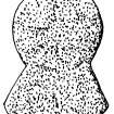
Lower churchyard. Disc-headed gravemarker of sandstone, broken across the foot of the gabled section. It is 0.52m in surviving height and the disc is 0.33m in diameter. Both faces of the disc are much weathered, but there are possible traces of a cross on one face.
Fisher 2001.
Field Visit (31 March 2010)
This disc-headed grave marker, which is situated in the lower graveyard some 30m S of the medieval church (NS05SE 5.00), is as described by Fisher. It and another (NS05SE 5.15), 2m to the S, are two of a handful of medieval grave markers that have not been removed to Bute Museum (NS06SE 122).
Visited by RCAHMS (GFG) 31 March 2010.


