Pricing Change
New pricing for orders of material from this site will come into place shortly. Charges for supply of digital images, digitisation on demand, prints and licensing will be altered.
Upcoming Maintenance
Please be advised that this website will undergo scheduled maintenance on the following dates:
Thursday, 9 January: 11:00 AM - 3:00 PM
Thursday, 23 January: 11:00 AM - 3:00 PM
Thursday, 30 January: 11:00 AM - 3:00 PM
During these times, some functionality such as image purchasing may be temporarily unavailable. We apologise for any inconvenience this may cause.
Bute, St Blane's
Cross Base (Early Medieval), Socketed Stone (Early Medieval), Millstone (Period Unassigned)(Possible)
Site Name Bute, St Blane's
Classification Cross Base (Early Medieval), Socketed Stone (Early Medieval), Millstone (Period Unassigned)(Possible)
Alternative Name(s) Carved Stone 13
Canmore ID 301999
Site Number NS05SE 5.13
NGR NS 09498 53405
Datum OSGB36 - NGR
Permalink http://canmore.org.uk/site/301999
- Council Argyll And Bute
- Parish Kingarth
- Former Region Strathclyde
- Former District Argyll And Bute
- Former County Buteshire
Reference (1984)
Photographic Record (1993)
Measured Survey (1994)
Reference (2001)
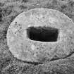
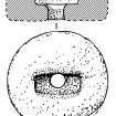
Circular socket-stone of sandstone in lower churchyard. It measures 0.84m in diameter and 0.31m in maximum thickness, the upper surface being slightly domical. The socket is 0.36m long and 0.17m in both width and depth. The stone may have been used at some period as a millstone, the floor of the socket being pierced by a circular hole 120mm in diameter. (Cross 1984, B31).
Fisher 2001.
Field Visit (31 March 2010)
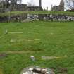
This cross-base, which is situated in the lower graveyard some 35m S of the chancel of the medieval church (NS05SE 5.00), is one of two in the vicinity, the other (NS05SE 10) lying about 70m N of the chancel. The cross-base is as described by Fisher.
Visited by RCAHMS (GFG) 31 March 2010.
Field Visit (21 March 2012)
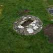
This cross-base or socket stone, which is situated within the southern burial-ground, is as previously described. However, there is little evidence to support the previous suggestion that it has ever been used as a millstone (Fisher 2001, 75). The stone is not circular on plan and the edge that is rough and slightly flattened appears to be natural rather than broken or eroded.
Visited by RCAHMS (JRS) 21 March 2012.


