Accessibility

Font Size

100% 150% 200%

Background Colour

Default Contrast
Close Reset

Gillies Burn

Souterrain (Prehistoric)(Possible), Unenclosed Settlement (Period Unassigned)

Site Name Gillies Burn

Classification Souterrain (Prehistoric)(Possible), Unenclosed Settlement (Period Unassigned)

Alternative Name(s) Carpow House Policies

Canmore ID 30105

Site Number NO21NW 46

NGR NO 20883 17979

Datum OSGB36 - NGR

Permalink http://canmore.org.uk/site/30105

Ordnance Survey licence number AC0000807262. All rights reserved.
Canmore Disclaimer. © Bluesky International Limited 2025. Public Sector Viewing Terms

Toggle Aerial | View on large map

Digital Images

Oblique aerial view.
Oblique aerial view.Oblique aerial view.Oblique aerial view.Oblique aerial view.Oblique aerial view.Oblique aerial view.Gillies Burn, NO21NW 46, Ordnance Survey index card, page number 2, RectoOblique aerial view.Oblique aerial view.Oblique aerial view.Oblique aerial view.Oblique aerial view.Oblique aerial view.Carpow and Gillies Burn, oblique aerial view, taken from the WNW, centred on the cropmarks of a Roman Fort, a Roman enclosure, ring-ditch and an unenclosed settlement. Mains of Carpow farmsteading is visible in the centre right half of the photograph.Oblique aerial view.Oblique aerial view.Oblique aerial view.Oblique aerial view.Oblique aerial view.Oblique aerial view.Oblique aerial view.Oblique aerial view.Oblique aerial view.Oblique aerial view.Oblique aerial view.Carpow and Gillies Burn, oblique aerial view, taken from the NE, centred on the cropmarks of a Roman Fort, a Roman enclosure and an unenclosed settlement. The cropmarks of a Roman aqueduct and a ring-ditch, and Mains of Carpow farmsteading are visible in the top half of the photograph, and linear cropmarks are shown in the bottom centre half.Carpow and Gillies Burn, oblique aerial view, taken from the SE, centred on the cropmarks of a Roman Fort, a Roman enclosure, ring-ditch and an unenclosed settlement. Mains of Carpow farmsteading is visible in the bottom left-hand corner of the photograph.Oblique aerial view.Oblique aerial view.Oblique aerial view.Oblique aerial view.Oblique aerial view.Gillies Burn, NO21NW 46, Ordnance Survey index card, page number 1, RectoOblique aerial view.Oblique aerial view.Oblique aerial view.Oblique aerial view.Oblique aerial view.Oblique aerial view.Carpow and Gillies Burn, oblique aerial view, taken from the SW, centred on the cropmarks of a Roman Fort, a Roman enclosure, ring-ditch and an unenclosed settlement. Mains of Carpow farmsteading and the cropmarks of a Roman aqueduct are visible in the bottom half of the photograph.Oblique aerial view.Oblique aerial view.Oblique aerial view.Oblique aerial view.Aerial viewGillies Burn, NO21NW 46, Ordnance Survey index card, RectoOblique aerial view.Oblique aerial view.Oblique aerial view.Aerial viewOblique aerial view.Oblique aerial view.Oblique aerial view.Oblique aerial view.Oblique aerial view.Oblique aerial view.Oblique aerial view.Carpow and Gillies Burn, oblique aerial view, taken from the NNW, centred on the cropmarks of a Roman Fort, a Roman enclosure, a ring-ditch and an unenclosed settlement. Mains of Carpow farmsteading is visible in the top right-hand corner of the photograph, and linear cropmarks are shown in the bottom left-hand corner.Oblique aerial view.Oblique aerial view.Oblique aerial view.Aerial viewOblique aerial view.Oblique aerial view.Oblique aerial view.Oblique aerial view.Oblique aerial view.Oblique aerial view

Administrative Areas

  • Council Perth And Kinross
  • Parish Abernethy (Perth And Kinross)
  • Former Region Tayside
  • Former District Perth And Kinross
  • Former County Perthshire

Archaeology Notes

NO21NW 46 20883 17979

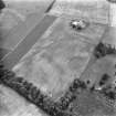
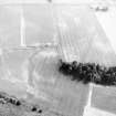
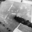
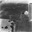
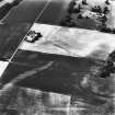
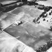
These cropmarks were previously described as a possible house platform.

(Undated) information in NMRS.

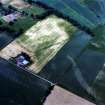
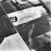
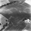
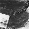
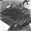
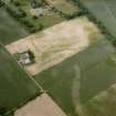
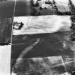
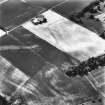
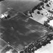
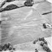
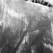
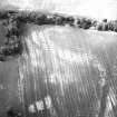
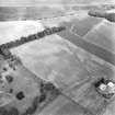
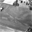
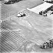
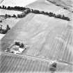
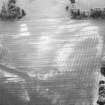
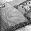
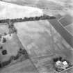
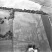
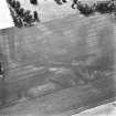
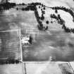
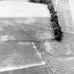
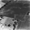
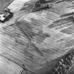
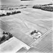
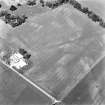
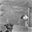
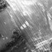
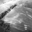
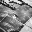
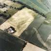
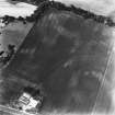
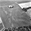
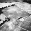
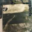
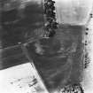
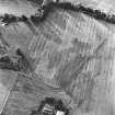
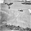
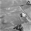
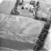
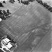
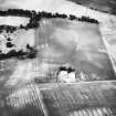
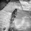
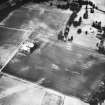
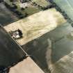
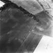
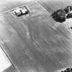
Aerial photography (RCAHMSAP 1983, 1986, 1990, 1992, and 1994; C Martin 1994) has revealed the cropmarks of an unenclosed round-house and what may be a souterrain on the line of the eastern rampart of the Roman fortress at Carpow (NO21NW 24.00) and some 300m ENE of Carpow House (NO21NW 66.00).

The round-house is represented by an oval macula about 8m in maximum diameter, which has been observed in several seasons of aerial reconnaissance. The possible souterrain, however, tends to be a more shadowy feature, but it is quite well-defined on photographs taken in 1983; these show the course of the passage curling round the N side of the round-house from a point on the SW, and disappearing at the edge of the fortress ditches on the NNE after a distance of about 20m.

Information from RCAHMS (JRS), 4 February 1997.

Activities

Aerial Photographic Transcription (31 December 1993)

An aerial transcription was produced from oblique aerial photographs. Information from Historic Environment Scotland (BM) 31 March 2017.

References

MyCanmore Image Contributions


Contribute an Image

MyCanmore Text Contributions