
Pricing Change
New pricing for orders of material from this site will come into place shortly. Charges for supply of digital images, digitisation on demand, prints and licensing will be altered.
Bute, St Ninian's Point


Well (Period Unassigned)(Possible)
Site Name Bute, St Ninian's Point
Classification Well (Period Unassigned)(Possible)
Canmore ID 300824
Site Number NS06SW 55
NGR NS 03458 61156
Datum OSGB36 - NGR
Permalink http://canmore.org.uk/site/300824

- Council Argyll And Bute
- Parish North Bute
- Former Region Strathclyde
- Former District Argyll And Bute
- Former County Buteshire
NS06SW 55 NS 03458 61156.
139. St Ninian's Point. NS 03458 61156. Well (possible), fair condition, 5 - 10th century AD.
This site was noted during a coastal zone assessment survey undertaken by CFA Archaeology Ltd to characterise the state of coastal erosion and the threat it poses to cultural heritage sites. A gazetteer in the report included a note of existing records and new sites when discovered. Where the site was located, notes included condition, period/date and recommendations.
Commissioned by The Scape Trust and Firth of Clyde Forum on behalf of Historic Scotland.
Cressey and Johnson 2004.
Field Visit (December 2003)
This site was noted during a coastal zone assessment survey undertaken by CFA Archaeology Ltd to characterise the state of coastal erosion and the threat it poses to cultural heritage sites. A gazetteer in the report included a note of existing records and new sites when discovered. Where the site was located, notes included condition, period/date and recommendations.
Commissioned by The Scape Trust and Firth of Clyde Forum on behalf of Historic Scotland.
Cressey and Johnson 2004
Measured Survey (2009 - 2010)
A series of measured drawings undertaken as part of ACFA's CARES project.
Field Visit (2009 - 2010)
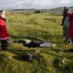
This is one of two wells on St Ninian’s Point. It is a carefully-built stone enclosure to a small pool which is normally around 0.3m deep but, at the time of our visit in late May 2010, had a depth of only 0.1m. A sequence of 4 shallow steps 0.6m wide leads down into the water from the north side. It has been suggested that it was built as a baptismal well associated with the nearby St Ninian’s Chapel, rather than a drinking well, although other local information states that it was built in recent times. A few stones around the edge of the well may suggest that the well was once enclosed with a small structure some 3m in diameter.

