
Bute, Little Kilchattan


Farmstead (Period Unassigned)
Site Name Bute, Little Kilchattan
Classification Farmstead (Period Unassigned)
Canmore ID 300756
Site Number NS15NW 30
NGR NS 10126 56614
Datum OSGB36 - NGR
Permalink http://canmore.org.uk/site/300756


- Council Argyll And Bute
- Parish Kingarth
- Former Region Strathclyde
- Former District Argyll And Bute
- Former County Buteshire
NS15NW 30 10126 56614
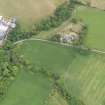
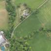
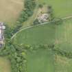
Little Kilchattan is a working farmsteading comprising a mixture of 19th and 20th century buildings, none of which was recorded on the date of visit. ‘Kilcatton Beg’ is depicted on Roy’s Military Map (1747-55) and a contemporary estate map (Foulis 1758-9) shows three buildings and an enclosure on a farm of 134 Scots acres (about 70 hectares). Four roofed buildings are shown here on the 1st edition of the OS 6-inch map (Buteshire 1869, Sheet CCXV).
Information from RCAHMS (GFG) 25 March 2010.
Antiquarian Mapping (1747 - 1755)
Antiquarian Mapping (1758 - 1759)
Aerial Photography (1935 - 1938)
An collection of aerial photographs taken by Andrew P Hunter from 1935 to 1938. Digitised by Andrew B Wilson in 2008.
Note (25 March 2010)
Little Kilchattan is a working farmsteading comprising a mixture of 19th and 20th century buildings, none of which was recorded on the date of visit. ‘Kilcatton Beg’ is depicted on Roy’s Military Map (1747-55) and a contemporary estate map (Foulis 1758-9) shows three buildings and an enclosure on a farm of 134 Scots acres (about 70 hectares). Four roofed buildings are shown here on the 1st edition of the OS 6-inch map (Buteshire 1869, Sheet CCXV).
Information from RCAHMS (GFG) 25 March 2010.

