
Pricing Change
New pricing for orders of material from this site will come into place shortly. Charges for supply of digital images, digitisation on demand, prints and licensing will be altered.
Faraid Head


Triangulation Pillar (19th Century) - (20th Century)
Site Name Faraid Head
Classification Triangulation Pillar (19th Century) - (20th Century)
Canmore ID 296189
Site Number NC37SE 14
NGR NC 38784 71582
Datum OSGB36 - NGR
Permalink http://canmore.org.uk/site/296189


- Council Highland
- Parish Durness
- Former Region Highland
- Former District Sutherland
- Former County Sutherland
Field Visit (2008)
NC37SE 14 38784 71582
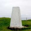
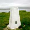
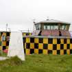
This concrete Ordnance Survey triangulation pillar is situated on the highest part of Faraid Head, immediately W of the main Defence Estates range control building (NC37SE 4). It measures 0.65m square at the base, with narrow chamfered corners, tapering to a flat top (0.4m square) at a height of 1.23m, where there is a brass mounting plate and retaining hoops for a theodolite. A brass flush bracket on the N side of the pillar bears the number S6111. The pillar is now redundant.
(CWTC08 283)
Visited by RCAHMS (LAD, IP) 4 August 2008.

