
Bay Of Keisgaig


Hut(S) (Period Unassigned)
Site Name Bay Of Keisgaig
Classification Hut(S) (Period Unassigned)
Canmore ID 295890
Site Number NC26NW 8
NGR NC 24985 69437
NGR Description NC 24985 69437 and NC 24978 69459
Datum OSGB36 - NGR
Permalink http://canmore.org.uk/site/295890


- Council Highland
- Parish Durness
- Former Region Highland
- Former District Sutherland
- Former County Sutherland
Field Visit (2008)
NC26NW 8 24985 69437 and 24978 69459
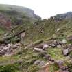
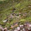
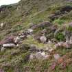
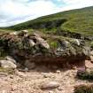
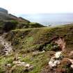
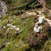
Two subrectangular huts, both reduced to grass- and heather-grown wall-footings, are situated immediately N of the Keisgaig River, some 115m NE of the building NC26NW 5.
The first hut (CWTC08 20) is set into the NW bank of a tributary stream and measures 3.5m from NE to SW by 2.8m transversely overall, with an entrance on the SE.
The second hut (CWTC08 19) lies 20m SSE of the first, perched on the nose of a narrow ridge that descends steeply towards the river. It measures 3m from NNE to SSW by 2.7m transversely overall, with an entrance on the ESE.
(CWTC08 19–20)
Visited by RCAHMS (JRS, JH), 5 August 2008.

