
Cnoc A' Ghiubhais


Marker Cairn(S) (Period Unknown)
Site Name Cnoc A' Ghiubhais
Classification Marker Cairn(S) (Period Unknown)
Canmore ID 295093
Site Number NC27SE 31
NGR NC 26659 70313
NGR Description NC 26659 70313 and NC 26670 70318
Datum OSGB36 - NGR
Permalink http://canmore.org.uk/site/295093


- Council Highland
- Parish Durness
- Former Region Highland
- Former District Sutherland
- Former County Sutherland
Field Visit (2008)
NC27SE 31 26659 70313 and 26670 70318
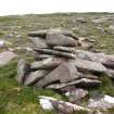
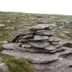
Two slab-built marker cairns are situated high up on the stony N shoulder of Cnoc a' Ghiubhais (298m OD), a prominent steep-sided hill 4km SSE of Cape Wrath.
The first cairn (CWTC08 25), which is situated on top of a large boulder, measures about 1m in diameter and 0.7m in height.
The second cairn (CWTC08 26), which stands 10m to the ENE of the first, measures up to 1.3m in diameter and 1m in height.
(CWTC08 25–26)
Visited by RCAHMS (JRS, JH) 5 August 2008.

