
Dunan Mor


Boundary Stone (Period Unassigned)(Possible)
Site Name Dunan Mor
Classification Boundary Stone (Period Unassigned)(Possible)
Canmore ID 295079
Site Number NC27SE 26
NGR NC 25855 74305
Datum OSGB36 - NGR
Permalink http://canmore.org.uk/site/295079


- Council Highland
- Parish Durness
- Former Region Highland
- Former District Sutherland
- Former County Sutherland
Field Visit (6 August 2008)
NC27SE 26 25855 74305
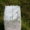
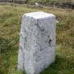
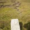
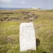
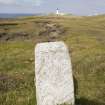
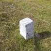
What is probably a boundary stone has been set up immediately N of the public road (NC27SE 41) that links a slipway on the Kyle of Durness (NC 3708 6603) to the lighthouse (NC27SE 3.00) at Cape Wrath, some 450m SSW of the latter. It is a grey granite pillar measuring 0.3m square at the base, rising 0.66m to a flat top 0.23m square. A narrow incised groove, which runs across the top of the stone from N to S, probably indicates the alignment of a boundary.
The pillar is not depicted on either the 1st or 2nd edition of the OS 6-inch map (Sutherland 1878, sheet 1; 1908, sheet 1), but it is shown on modern OS digital maps.
(CWTC08 013)
Visited by RCAHMS (JRS, JH) 5 August 2008.

