
Pricing Change
New pricing for orders of material from this site will come into place shortly. Charges for supply of digital images, digitisation on demand, prints and licensing will be altered.
Inshore


Milestone (19th Century)
Site Name Inshore
Classification Milestone (19th Century)
Canmore ID 295076
Site Number NC36NW 5
NGR NC 32728 69195
Datum OSGB36 - NGR
Permalink http://canmore.org.uk/site/295076


- Council Highland
- Parish Durness
- Former Region Highland
- Former District Sutherland
- Former County Sutherland
Field Visit (6 August 2008)
NC36NW 5 32728 69195
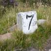
This milestone is situated 250m SE of the former shepherd’s house at Inshore (NC36NW 2), on the N side of the public road (NC36NW 18) that links a slipway on the Kyle of Durness (NC 3708 6603) to the lighthouse (NC27SE 3.00) at Cape Wrath. Rectangular in section, the granite block measures 0.29m in breadth by 0.19m in thickness and 0.39m in height. The front face has been painted white and the incised number seven, denoting the distance in miles to the lighthouse, has been painted black.
The exact date that the milestone was erected is not known, but it was probably soon after the road was adopted as a public highway in 1833 and it was certainly in place by 1874, when it was surveyed for the 1st edition of the OS 6-inch map (Sutherland 1878, sheet V). A local tradition that the milestones along the 11 mile length of the road were fabricated by lighthouse keepers cannot be substantiated, but it would provide an explanation why there is a variation in their respective designs and dimensions.
(CWTC08 093)
Visited by RCAHMS (JRS, JH) 10 August 2008.

