
Dunan Mor


Milestone (19th Century)
Site Name Dunan Mor
Classification Milestone (19th Century)
Canmore ID 295070
Site Number NC27SE 21
NGR NC 25948 73399
Datum OSGB36 - NGR
Permalink http://canmore.org.uk/site/295070


- Council Highland
- Parish Durness
- Former Region Highland
- Former District Sutherland
- Former County Sutherland
Field Visit (2008)
NC27SE 21 25948 73399
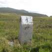
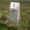
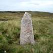
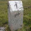
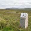
This milestone is situated on the SW verge of the public road (NC27SE 41) that links a slipway on the Kyle of Durness (NC 3708 6603) to the lighthouse (NC27SE 3.00) at Cape Wrath. It is a dressed granitic gneiss block measuring 0.3m square in section and 0.8m in height. The top of its front (NE) face, which is faceted, has been painted white and the incised number one, denoting the distance in miles to the lighthouse, has been painted black. The top of the rear of the stone is also facetted, but the facet here is narrower and shallower.
The exact date that the milestone was erected is not known, but it was probably soon after the road was adopted as a public highway in 1833 and it was certainly in place by 1874, when it was surveyed for the 1st edition of the OS 6-inch map (Sutherland 1878, sheet I). A local tradition that the milestones along the 11 mile length of the road were fabricated by lighthouse keepers cannot be substantiated, but it would provide an explanation why there is a variation in their respective designs and dimensions.
(CWTC08 102)
Visited by RCAHMS (AL, IP) 6 August 2008.

