
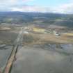
Evanton Airfield, Cromarty Firth


Fish Trap(S) (Period Unassigned)
Site Name Evanton Airfield, Cromarty Firth
Classification Fish Trap(S) (Period Unassigned)
Alternative Name(s) Firth Of Cromarty
Canmore ID 294277
Site Number NH66NW 87
NGR NH 632 662
NGR Description Centred NH 632 662
Datum OSGB36 - NGR
Permalink http://canmore.org.uk/site/294277


- Council Highland
- Parish Kiltearn
- Former Region Highland
- Former District Ross And Cromarty
- Former County Ross And Cromarty
NH66NW 87 centred 632 662
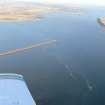
Fish Traps (AP) and fish trap mounds.
CFA/MORA Coastal Assessment Survey 1998.
Aerial Photographic Interpretation (1998)
Fish Traps (AP) and fish trap mounds.
CFA/MORA Coastal Assessment Survey 1998.

