|
Manuscripts |
MS 2776/1/1 |
Historic Scotland Archive Project |
Survey archive: Site record sheets, site record sheets with field notes and monument forms from the Inner Moray Firth (Moray, Beauly and Cromarty Firth) Coastal Assessment Survey. Sheet 1. |
9/1998 |
Item Level |
|
|
Prints and Drawings |
BD 104/1/1 |
Historic Scotland Archive Project |
Survey archive: 1:25,000 OS Pathfinder map depicting site locations from the Moray, Beauly and Cromarty Firth Coastal Assessment Survey, Sheet 1. |
9/1998 |
Item Level |
|
 |
On-line Digital Images |
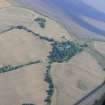
DP 343159 |
Papers of James Sloan Bone, landscape historian, Inverness, Highland, Scotland |
An oblique aerial view of Tarradale, near Muir of Ord, Black Isle, looking SE |
1/10/2013 |
Item Level |
|
 |
On-line Digital Images |
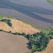
DP 343605 |
Papers of James Sloan Bone, landscape historian, Inverness, Highland, Scotland |
Aerial view of Tarradale House and mouth of River Beauly, Black Isle, looking S. |
16/8/2016 |
Item Level |
|
 |
On-line Digital Images |
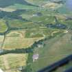
DP 343654 |
Papers of James Sloan Bone, landscape historian, Inverness, Highland, Scotland |
Oblique aerial view of the Bellevue and Tarradale Mains area, N shore of Beauly Firth, looking NE. |
18/7/2018 |
Item Level |
|


