
Pricing Change
New pricing for orders of material from this site will come into place shortly. Charges for supply of digital images, digitisation on demand, prints and licensing will be altered.
Knockali


Hut Circle(S) (Prehistoric)
Site Name Knockali
Classification Hut Circle(S) (Prehistoric)
Alternative Name(s) Drumturn Burn
Canmore ID 29007
Site Number NO15NE 12
NGR NO 1541 5881
NGR Description Centred on NO 154 588
Datum OSGB36 - NGR
Permalink http://canmore.org.uk/site/29007


- Council Perth And Kinross
- Parish Alyth
- Former Region Tayside
- Former District Perth And Kinross
- Former County Perthshire
Field Visit (24 April 1974)
NO15NE 12 centred 154 588.
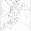
Centred at NO 154 588 is a settlement of 13 circular stone-walled huts (A - N), and a contemporary field system marked by stone clearance heaps, lynchets and ruinous walls.
'A' is a 'Dalrulzion' hut in a poor state of preservation. It measures 8.0m in internal diameter and 15.0m between the centres of the outer wall. The entrance is in the SSE.
'B' is 9.5m in diameter between the centres of an ill-defined wall, with an entrance in the SE.
'C' is 7.5m in diameter internally with several inner facing stones evident, and one or two outer facing stones in the SW giving a wall thickness here of 1.3m. Entrance in the SSE.
'D', visible as a platform in the S-facing slope, is 12.0m in diameter between the centres of an ill-defined wall, with the entrance in the SSE.
'E', set well into the base of a slope, shows both inner and outer faces to be built of dry stone walling surviving to a height of three courses. It measures 6.5m internally with the wall 1.7m thick. Entrance in the SSE.
'F' and 'G' are ill-defined, measuring respectively 7.0m and 8.0m in diameter with no entrances visible.
'H' is 10.0m in diameter internally with the inner face occasionally visible in a wall of indeterminate thickness. Entrance in the SE.
'J', adjacent to 'H', is 10.5m internally, with several inner facing stones visible and one outer facing stone in the SW giving a wall thickness of 1.8m. The mutilated entrance is in the SE. A wall curves around the back of 'J' and 'H', c. 2.0m outside the hut walls, possibly to shed water running down from the slope into which the huts are set. 'K' is 8.2m in internal diameter with the inner face occasionally visible in a wall of indeterminate thickness. The entrance in the SE is flanked by two stone jambs 1.0m apart.
'L' is 7.5m internally with the wall spread to 2.5m, and an ill-defined entrance in the SE.
'M', adjacent to the W arc of 'L', measures 6.0m between the centres of a wall spread to 2.5m. Entrance in the SE.
'N' is 12.0m between the centres of a wall of uncertain thickness. Entrance in the E. About 50.0m S of 'D' is a poorly-preserved "long-house" (32m E-W by 6m) with bowed walls and rounded gable-ends. Attached to the W end is a contemporary oval enclosure (15m E-W by 13m). Impinging on the NW arc of the enclosure is a circular platform 11.5m in diameter, possibly another hut circle.
Field system delineated on 6" sheet. Surveyed at 1:10,000.
Visited by OS (AA) 24 April 1974
Measured Survey (26 October 1987)
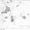
RCAHMS surveyed a group of five hut circles (Nos. 8-12; OS 'H'-'M') at Drumturn Burn by self-reducing alidade and plane-table on 26 October 1987 at a scale of 1:500. The resultant plan was redrawn in ink and published at a scale of 1:1000 (RCAHMS 1990, Fig. 124.4A).
Measured Survey (1987)
RCAHMS surveyed the hut-circles, field systems and Pitcarmick-type buildings at Drumturn Burn/Knockali in 1987 at a scale of 1:2500. The resultant plan was redrawn in ink and published at a scale of 1:5000 (RCAHMS 1990, Fig. 124.4C).
Field Visit (5 April 1988)
A total of twelve hut-circles are situated on the NE flank of Knockali and on the SW and S faces of an un-named hill to the NE.
1. NO 1557 5903 (OS 'A') This double-walled hut-circle is situated on a broad terrace and measures 9m in diameter within a low rubble wall 1.3m thick and 0.1m high. This wall has been mutilated on its N side and is partially overlain by a later rubble wall. Overall the hut-circle measures 17.2m in diameter with the outer wall measuring 2m in thickness and 0.2m in height. Several outer facing stones of this wall are visible and the entrance (on the SSE) is faced on its W side by a large slab.
2. NO 1545 5903 (OS 'B') About 100m W of (1) there is a hut-circle which is situated on a narrow terrace; it measures 7.2m in diameter within a heather-covered bank measuring up to 2.2m in thickness and 0.3m in height. A few outer facing-stones are present and there is an entrance gap on the SE.
3. NO 1548 5888 (OS 'C') This hut-circle is situated on a steepish SW-facing slope into which the interior has been levelled on its N side. The front of the hut-circle sits upon a platform and it measures 7.5m in diameter within a wall 2.2m thick and 0.3m high. The inner face of this wall is faced with boulders and slabs set on edge and an outer face of boulders is present on the E and W sides of the entrance. The entrance which is on the SSE is flanked on its E side by a large slab which is set upright as part of the inner face.
4. NO 1554 5880 (OS 'D') Situated on an artificial platform on a steep SW-facing slope, this hut-circle measures 8.8m in diameter within a boulder-faced scarp 0.3m high on the N and NE and the edge of the level platform elsewhere. On the N and NE there is an upper stony bank measuring about 1m thick and it is partially overlain by a substantial rubble wall which approaches from the NW.
5. NO 1556 5879 (OS 'E') Situated about 15m ESE of (4) there is a well-preserved hut-circle at the base of a steep, craggy slope. It measures 6.3m in diameter within a wall (1.6m thick and 0.4m high) defined by an inner face of large boulders and upright slabs. On the N and NE the hut-circle has been levelled to a depth of about 1m and the outer face of large boulders (which is also present on the S side) rises up the slope to form a substantial inner-facing boulder-faced scarp.
The entrance is on the S side and is 1.2m wide.
6. NO 1556 5877 (OS 'G') Situated on a levelled platform about 15m S of (5) there is a small hut-circle which measures 6.8m in diameter within a low scarp (0.3m high) on the N side and a low rickle of stone elsewhere; the position of the entrance is not apparent.
7. NO 1555 5878 (OS 'F') A few metres WNW of (6) there is a D-shaped structure which was previously identified by the OS as a hut-circle.
The chord of the D lies to the SW and the building measures 6.3m NW-SE by 4.3m within a rubble bank which measures 0.6m thick and 0.2m high. There are the remains of both inner and outer faces but there is no obvious entrance gap.
8. NO 1529 5884 (OS 'H') This hut-circle is the most easterly of a group of five which are aligned in a row (NE-SW) along the SE face of a spur on the NE side of Knockali. It measures about 9m in diameter within a heather-covered wall measuring up to 2m in thickness and 0.6m in height. On the NW where the hut-circle has been levelled into the natural slope the inner edge of the wall is marked by a boulder and slab-faced scarp 1m high. There is little evidence of outer facing on the S side but there is an outer length of walling which arcs round the N side and continues to pass (J) and part of (K). There is an entrance (2m wide) on the SSE.
9. NO 1528 5884 (OS 'J') This hut-circle lies immediately SW of (H) and is tangential to it. It measures 9.4m in diameter within a rubble wall some 1.1m thick and 0.4m high. The inner face of the wall is marked by a dis-continuous row of boulders and slabs which line a scarp on the N side where the structure has been levelled into the natural slope. A few outer facing-stones are visible on the SW and there is an entrance gap (1.1m wide) on the SSE. Within the hut-circle there is a ring-ditch feature (about 3m broad and 0.2m deep) which encloses a central area measuring about 4m in diameter.
10. NO 1527 5883 (OS 'K') Situated immediately SW of (9) this hut-circle has also been levelled into the natural slope and measures 8.5m in diameter within an intermittent boulder-faced scarp (0.7m high) on the N and a rubble wall (1.4m thick and 0.3m high) elsewhere. There appears to be no outer face visible and the entrance on the SSE measures 0.8m wide between two upright boulders one of which is 0.8m high.
11. NO 1526 5883 (OS 'L') A few metres SW of (10) there are the remains of a hut-circle which may be slightly levelled into the natural slope.
It measures 7m in diameter within a heather-covered bank (1.7m thick and 0.4m high) and several facing-stones are visible on the SW (outer) and W (inner). The entrance is on the SE and measures about 1.2m in width.
12. NO 1525 5883 (OS 'M') Immediately W of (11) there is a small structure which measures 4.5m in diameter within an amorphous rubble bank which incorporates large boulders but appears to have no formal face. It has been levelled into the slope on the N side and a depression in the wall on the SE probably indicates the position of an entrance.
13. NO 1530 5874 (OS 'N') The remains of this hut-circle are situated on a narrow terrace on an E-facing slope, and measure 10.3m in diameter within a heather-covered bank 2.3m thick and 0.3m high. The interior has been levelled into the slope and the inner and outer edges of the wall are marked by facing-stones on the W and SE sides respectively.
The poorly-preserved entrance, which appears to have been fairly wide, is situated on the E.
Visited by RCAHMS (JRS) 5 April 1988.
RCAHMS 1990
Field Visit (25 November 2015)
Alder Archaeology was commissioned by John Clegg & Co, Chartered Surveyors and Forestry Agents to undertake a desk-based assessment and walkover survey on the site of a proposed forestry development at Drumfork, Blacklunans, near Blairgowrie, Perth and Kinross. The walkover (Alder site code (BW09) was done on 25 November 2015 in mainly dry, windy weather condition. The site had previously been surveyed by the RCAHMS in 1987-8 and only one additional site was recorded: a short stretch of drystone wall beside a rock outcrop, possibly part of a shelter.
Information from David Perry (Alder Archaeology Ltd).

