
Following the launch of trove.scot in February 2025 we are now planning the retiral of some of our webservices. Canmore will be switched off on 24th June 2025. Information about the closure can be found on the HES website: Retiral of HES web services | Historic Environment Scotland
Mains Of Raddery


Farmstead (Period Unassigned)
Site Name Mains Of Raddery
Classification Farmstead (Period Unassigned)
Canmore ID 288787
Site Number NH75NW 336
NGR NH 71038 59590
Datum OSGB36 - NGR
Permalink http://canmore.org.uk/site/288787


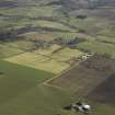
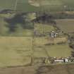
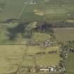
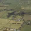
- Council Highland
- Parish Rosemarkie
- Former Region Highland
- Former District Ross And Cromarty
- Former County Ross And Cromarty

