 |
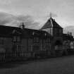
On-line Digital Images |
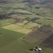
DP 024737 |
RCAHMS Aerial Photography Digital |
General oblique aerial view centred on the farmsteading and the school, taken from the WNW. |
3/4/2007 |
Item Level |
|
 |
On-line Digital Images |
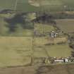
DP 024738 |
RCAHMS Aerial Photography Digital |
Oblique aerial view centred on the farmsteading, taken from the SW. |
3/4/2007 |
Item Level |
|
 |
On-line Digital Images |
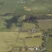
DP 024739 |
RCAHMS Aerial Photography Digital |
Oblique aerial view centred on the farmsteading, taken from the SW. |
3/4/2007 |
Item Level |
|
 |
On-line Digital Images |
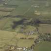
DP 024740 |
RCAHMS Aerial Photography Digital |
Oblique aerial view centred on the farmsteading, taken from the SSW. |
3/4/2007 |
Item Level |
|
 |
On-line Digital Images |
SC 1947161 |
Scottish Development Department |
Raddery Mains, South Elevation, Rosemarkie Parish, Highland |
13/9/1979 |
Item Level |
|
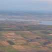 |
On-line Digital Images |
DP 342560 |
Papers of James Sloan Bone, landscape historian, Inverness, Highland, Scotland |
Aerial view of the Black Isle and Invergordon, looking N. |
28/1/2012 |
Item Level |
|
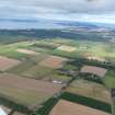 |
On-line Digital Images |
DP 342940 |
Papers of James Sloan Bone, landscape historian, Inverness, Highland, Scotland |
Aerial view of Raddery, near Rosemarkie, Black Isle, looking NE. |
4/10/2012 |
Item Level |
|


