
Pricing Change
New pricing for orders of material from this site will come into place shortly. Charges for supply of digital images, digitisation on demand, prints and licensing will be altered.
Drumlochy Castle


Tower House (Medieval)
Site Name Drumlochy Castle
Classification Tower House (Medieval)
Alternative Name(s) Drumlochy Castle
Canmore ID 28713
Site Number NO14NE 17
NGR NO 1576 4692
Datum OSGB36 - NGR
Permalink http://canmore.org.uk/site/28713


- Council Perth And Kinross
- Parish Blairgowrie
- Former Region Tayside
- Former District Perth And Kinross
- Former County Perthshire
NO14NE 17 1576 4694.
(NO 1576 4694) Castle (NR) (Site of)
OS 6" map, Perthshire, 2nd ed. (1901)
A few fragments, now converted into a cowshed, are all that remain of Drumlochy Castle, the former home of the Herons of Drumlochy. Dated 1542-1700.
D MacGibbon and T Ross 1889
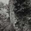
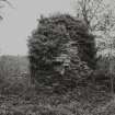
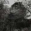
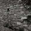
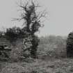
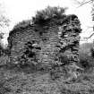
The S wall of Drumlochy Castle (8.0m long, 0.85m thick) survives to a height of about 4.0m, and incorporates a blocked central window, with a narrow slit window at the W end, where also are the fragmentary remains of a circular tower. This fragment is pierced by a wide-mouthed gunloop with a rectangular aperture different in style to the type in nearby Glasclune Castle. The wall appears to be the S side of a rectangular block measuring 10.5m x 8.0m, but the other sides are reduced to turf-covered foundations which are confused by being incorporated into a later, now ruinous, farm building, and the original plan of the castle is largely conjectural. Revised at 1:2500.
Visited by OS (IMT) 5 March 1973
Field Visit (July 1987)
All that visibly remains of the late 16th- or 17th-century tower-house of Drumlochy is a fragment of the S wall of the main block and part of a circular tower which was extruded on the W. The surviving masonry, which is of mortared rubble, measures 8.2m in length, 0.8m in thickness and up to 3.6m in height. There are two blocked window-openings and a key-hole gunloop. A number of moulded stones are incorporated in the ruinous walls of an adjacent steading.
Drumlochy was the property of the Heron family.
Visited by RCAHMS (IMS) July 1987
RCAHMS 1990.
Standing Building Recording (2004)
NO 1576 4694 The slight standing remains of Drumlochy Castle (NO14NE 17) were recorded stone-by-stone in May 2004. Parts of the principal SE wall and a small stair tower remain, the latter containing a wide-mouthed loop. The SE wall reduces in thickness to the NE, suggesting that there had been a coeval but less substantial range against that side of a tower. The site of the remainder of the tower must lie to the N and W of the existing fragment, and the corresponding low platform of ground indicates that much may still survive below the surface.
A general topographic survey of the site was enhanced with the details of standing structures and other landscape features. The site occupies the summit of a knoll. To the N this had been defined by a substantial wall of indeterminate date; further walling bounding the SE side may also be of early construction. The castle ruin occupies the E/SE part of a square enclosure defined by substantial rubble walls and, on the downslope side to the SSE, a stone-retained terrace. The latter drops to a further square enclosure, evidently the remains of a formal, probably parterre, garden. The SE side of this has been substantially terraced out over the steep slope beyond and has an open prospect over the glen below. At the E corner of this lower enclosure there is evidence for a possible garden building.
The substantial standing remains of a ruined farm steading exist to the NE of the tower ruin and comprise a probable 18th-century range and a series of 19th-century buildings, including barns, a cottage and a farmhouse.
The well-preserved remains of the formally designed landscape may have been contemporary with the tower, or at least relate to its later use (?in the 17th century). The site seems to have been abandoned in the 17th century, apparently following a destructive attack by the occupants of nearby Glasclune Castle, and little disturbed since.
The later farm steading is of considerable interest in its own right. It is a well-preserved complex of buildings that, for reasons as yet unexplained, was abandoned in toto, perhaps by the beginning of the 20th century. It appears to have been unaltered since that time and has not been extensively robbed following abandonment. It survives as a curious artefact of the age of 19th-century farm Improvement that may incorporate earlier elements.
Archive to be deposited in Perth and Kinross SMR and the NMRS.
T Addyman and K Macfadyen 2004
Archaeological Evaluation (31 January 2008 - 12 March 2008)
NO 1576 4690 (centred on) An evaluation was carried out on 31 January and 12 March 2008 before the building of a new house next to the ruins of the castle. The excavation of 12 test pits and two trial trenches showed that very little evidence survives below ground for the extent and character of the castle and ancillary features. However, some evidence has already been recorded in the topography of the site and the remains of the former steading.
Archive: RCAHMS
Funder: Mr William Thomson
David Bowler and Claire Casey (SUAT Ltd), 2008

