Accessibility

Font Size

100% 150% 200%

Background Colour

Default Contrast
Close Reset

Cambusmichael

Archaeological Feature(S) (Period Unknown), Enclosure(S) (Period Unknown), Grange (Medieval)

Site Name Cambusmichael

Classification Archaeological Feature(S) (Period Unknown), Enclosure(S) (Period Unknown), Grange (Medieval)

Alternative Name(s) Cambusmichael Church

Canmore ID 28656

Site Number NO13SW 30

NGR NO 1151 3248

NGR Description Centred on NO 1151 3248

Datum OSGB36 - NGR

Permalink http://canmore.org.uk/site/28656

Ordnance Survey licence number AC0000807262. All rights reserved.
Canmore Disclaimer. © Bluesky International Limited 2025. Public Sector Viewing Terms

Toggle Aerial | View on large map

Digital Images

Digital image of Cambusmichael, oblique aerial view, taken from the SSW, centred on the cropmarks of the Grange. Cambusmichael Church is visible in the top half of the photograph.
Digital image of Cambusmichael, oblique aerial view, taken from the SSW, centred on the cropmarks of the Grange. Cambusmichael Church is visible in the top half of the photograph.Cambusmichael, oblique aerial view taken from the W, centred on the cropmarks of two seperate enclosures, settlement traces and a grange.Oblique aerial view centred on the cropmarks of the enclosure and grange, taken from the W.Oblique aerial view.Cambusmichael, NO13SW 30, Ordnance Survey index card, RectoNO13SW 30 and 41, Ordnance Survey index card, RectoOblique aerial view.Oblique aerial view.Oblique aerial view.Cambusmichael, oblique aerial view taken from the NW, centred on the cropmarks of two seperate enclosures, settlement traces and a grange.Oblique aerial view centred on the cropmarks of the enclosure and grange with the ruins of the burial ground and church adjacent, taken from the S.Oblique aerial view.Cambusmichael, oblique aerial view, taken from the NE, centred on the cropmarks of the Grange. Cambusmichael Church is visible in the foreground.Cambusmichael, oblique aerial view, taken from the NE, centred on the cropmarks of the Grange. Cambusmichael Church is visible in the foreground.Oblique aerial view.Oblique aerial view.Cambusmichael, NO13SW 30, Ordnance Survey index card, RectoCambusmichael, NO13SW 30, Ordnance Survey index card, RectoOblique aerial view.Oblique aerial view.Oblique aerial view centred on the cropmarks of the enclosure and grange with the ruins of the burial ground and church adjacent, taken from the SW.Oblique aerial view.Cambusmichael, oblique aerial view taken from the S, centred on the cropmarks of two seperate enclosures, settlement traces and a grange.Cambusmichael, oblique aerial view, taken from the WNW, centred on the cropmarks of the Grange. Cambusmichael Church is visible in the centre left of the photograph.

Administrative Areas

  • Council Perth And Kinross
  • Parish St Martins
  • Former Region Tayside
  • Former District Perth And Kinross
  • Former County Perthshire

Activities

Field Visit (28 February 1969)

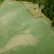
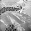
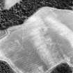
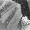
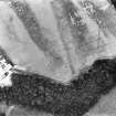
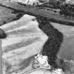
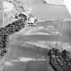
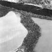
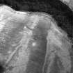
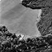
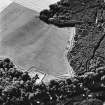
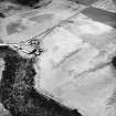
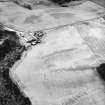
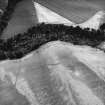
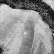
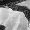
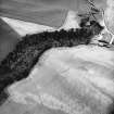
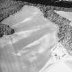
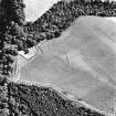
Cropmarks of enclosures Cambusmichael, visible on St Joseph AP. Both sites are on relatively flat ground in a ploughed field. There is no evidence on the ground. Surveyed at 1/2500 from AP.

Visited by OS (RD) 29 February 1969

Note (June 1992)

NO13SW 30 1151 3248.

For another rectilinear enclosure in the same field, see NO13SW 41.

An area of about 1.5ha around Cambusmichael church (NO13SW 17) is enclosed by two widely-spaced ditches which are only visible as cropmarks on aerial photographs. The outer ditch is the broader of the two, lying between 26m and 40m outside the inner, and there is a probable entrance close to its E end.

These enclosures probably indicate the site of an early administrative centre, either belonging to the Augustinian abbey at Scone, or to the estate that was granted to the monks by David I (1124-53).

Visited by RCAHMS (SH/AW) June 1992.

References

MyCanmore Image Contributions


Contribute an Image

MyCanmore Text Contributions