
Stanley, Cambusmichael Church And Burial-ground


Burial Ground (Medieval), Church (Medieval)
Site Name Stanley, Cambusmichael Church And Burial-ground
Classification Burial Ground (Medieval), Church (Medieval)
Canmore ID 28641
Site Number NO13SW 17
NGR NO 11566 32586
Datum OSGB36 - NGR
Permalink http://canmore.org.uk/site/28641


- Council Perth And Kinross
- Parish St Martins
- Former Region Tayside
- Former District Perth And Kinross
- Former County Perthshire
NO13SW 17 11566 32586
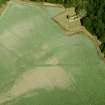
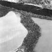
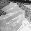
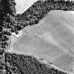
For enclosing earthworks (recorded as cropmarks) see NO13SW 30.
(NO 1156 3258) Cambusmichael Church (NR) (In ruins).
OS 6" map (1902)
Cambusmichael parish was united with St Martins about the beginning of the 18th century. The ruined church is 15th to 16th century.
New Statistical Account (NSA) 1845; D MacGibbon and T Ross 1897.
Field Visit (21 February 1969)
Generally as described and planned.
Visited by OS (RD) 21 February 1969.
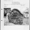
Photographic Survey (1986)
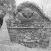
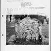
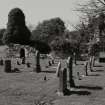
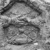
Recording of gravestones in the churchyard of Cambusmichael Church by Mrs Betty Willsher in 1986.
Field Visit (June 1989)
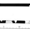
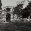
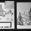
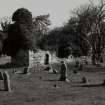
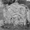
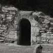
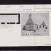
The church of the former parish of Cambusmichael stands as a roofless ruin in its burial-ground. Rectangular on plan, it measures 15.6m from ENE to WSW by 6.4m transversely overall; its walls are 0.9m thick and incorporate many ashlar blocks, possibly in re-use from an earlier building on the site. The gables stand to their full height and have chamfered offsets which coincide with projecting eaves courses (now largely vanished) on the side walls. The doorway is placed towards the W end of the S wall; it is semicircular-headed and wrought with a broad chamfer; the lintelled doorway embrasure incorporates in re-use a medieval coped grave-cover. Central to the S wall there is a small round-headed window, with the remains of two larger openings to either side.
The church is on record in the 12th century and may have gone out of use when the parish of Cambusmichael was united with St Martins at some time before 1693. It was ruinous by 1711 when an account states that there was another small ruinous chapel beside it in the burial-ground; there are no visible remains of this latter building.
Visited by RCAHMS (PC/IMS) June 1989.
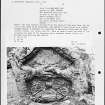
Measured Survey (19 May 1989)
RCAHMS surveyed Cambusmichael church (NO13SW 17) on 19 May 1989 with plane-table and alidade at a scale of 1:100. The resultant plan was redrawn in ink and published at a scale of 1:250 (RCAHMS 1994b, 130(A)).

