
St Martins


Standing Stone(S) (Prehistoric)
Site Name St Martins
Classification Standing Stone(S) (Prehistoric)
Alternative Name(s) Cupar Stone; Damside, Stone Row; Cairnbeddie
Canmore ID 28632
Site Number NO13SE 9
NGR NO 1595 3122
Datum OSGB36 - NGR
Permalink http://canmore.org.uk/site/28632


- Council Perth And Kinross
- Parish St Martins
- Former Region Tayside
- Former District Perth And Kinross
- Former County Perthshire
Publication Account (1865)
'Three large boulders set up edgeways, and part of a circular earthen bank. There is no local tradition regarding the stones but the Rev Park believes them to be the remains of a Druidical Temple. The name Cupar Stone is not well known locally but still appears on the estate map'.
Name Book 1865.
Field Visit (1965)
Mrs Stewart notes that several stones are missing and is able to deduce thus that this was a circle 24'6" (7.5m) in diameter and that the four remaining stones are the largest of the circle and occupy the S and W.
M E C Stewart 1965.
Field Visit (30 November 1970)
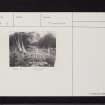
Situated on level ground, in the southern corner of a partially cleared wood, are three large stones (two recumbent) in a roughly straight line running NNE - SSW with a further recumbent stone partially embedded in a boundary bank.
The four stones are not certainly indicative of a circle and the authority for publishing them, the Rev Park, cannot be considered reliable. Mrs Stewart can have no further information and is clearly making several assumptions. Even if this were a stone circle it would be considerably larger than her 24ft diameter.
At a distance of 15.0m to the N of the stones is a segment of a slight curving bank with outer ditch, which terminates at each end on the boundary of the wood. The bank is 2.5m wide and the ditch 2.0m wide and 0.5m deep. It would appear to be a relatively modern work.
The name 'Cupar Stone' is not known locally.
Re-surveyed at 1/2500.
Visited by OS (JP), 30 November 1970.
Field Visit (20 April 1989)
Situated in the SE corner of a recently improved field and about 920m E of Cairnbeddie steading, there are the remains of a possible three-stone alignment. The N stone is erect and measures 1.65m from NE to SW by 0.7m in thickness and 1.05m in height; the central stone, 1m from the first, measures about 1.8m in diameter by 0.5m in thickness and has fallen; the third stone, 2.3m from the second, is also recumbent and measures 2.35m by 1.35m and is 0.5m thick.
Visited by RCAHMS (JRS), 20 April 1989.
Measured Survey (20 April 1989)
RCAHMS surveyed the standing stones at St Martins (NO13SE 9) with plane-table and alidade on 20 April 1989 at a scale of 1:125. The resultant plan was redrawn in ink.

