
Laggandhu


Hut Circle(S) (Prehistoric)
Site Name Laggandhu
Classification Hut Circle(S) (Prehistoric)
Canmore ID 285703
Site Number NJ01NE 77
NGR NJ 05794 18962
Datum OSGB36 - NGR
Permalink http://canmore.org.uk/site/285703


- Council Highland
- Parish Abernethy And Kincardine
- Former Region Highland
- Former District Badenoch And Strathspey
- Former County Inverness-shire
NJ01NE 77 05794 18962
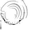
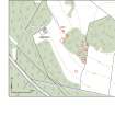
A group of at least five hut-circles (centred on NJ 05794 18962) is situated in a birch plantation 200m ESE of Laggandhu. The hut-circles are arranged in two tiers on a SW-facing slope, with two on the upper tier and three on the lower. The huts comprise levelled platforms dug into the slope at the rear to a depth of at least 2m, with well-defined aprons on their front edges. The platforms range in size from 11m to 17m in diameter and the aprons stand up to 1.5m in height. A curved stone revetment, composed of large boulders, defines the front edge of the western platform on the upper tier. An upright stone marks the S side of the entrance on the W side of SE platform on the lower tier. On the date of visit the site was largely obscured with a dense cover of bracken.
Visited by RCAHMS (TIP) 24 August 2006.
Project (March 2007)
Detailed measured survey was undertaken in the Braes of Abernethy, Highland, by RCAHMS over the course of one week in March 2007. The archaeological and architectural monuments recorded were identified as worthy of further attention during a survey undertaken in 2006 (see Project Event 555817). The survey was designed to record a representative sample of the sites recorded in 2006, particularly those that were otherwise under-represented in then National Monuments Record of Scotland (now the National Record of the Historic Environment (NRHE)). The Pictish barrow cemetery at Pityoulish is situated outside the area of the original survey, but the opportunity to record it in detail for the first time was thought to be too good a chance to miss. Accordingly two parts of the site were recorded – the group of four ditched mounds at the NE end (Canmore ID 15389) and a solitary kerbed cairn 230m to the SW (Canmore ID 15413).
Information from HES Survey and Recording (JRS) 18 April 2018.
Measured Survey (7 March 2007)
RCAHMS surveyed the hut-circle at Laggandhu (NJ01NE 77) on 7 March 2007 with plane-table and self-reducing alidade at a scale of 1:250. The plan was redrawn in vector graphics software.

