
Laintachan


Hut Circle (Prehistoric)
Site Name Laintachan
Classification Hut Circle (Prehistoric)
Canmore ID 284940
Site Number NJ01NE 62
NGR NJ 05903 18368
Datum OSGB36 - NGR
Permalink http://canmore.org.uk/site/284940


- Council Highland
- Parish Abernethy And Kincardine
- Former Region Highland
- Former District Badenoch And Strathspey
- Former County Inverness-shire
Field Visit (25 August 2006)
NJ01NE 62 NJ 05903 18368.
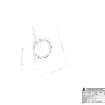
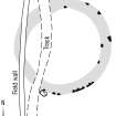
This hut-circle is situated in open birch woodland 300m SE of Laintachan farmsteading (NJ01NE 7). It measures 14.2m in diameter within a wall reduced to a grass-grown stony bank up to 3.4m in thickness and standing 0.5m in height on the N. Several inner and outer facing stones are visible, but parts of the wall appear to have been robbed to build the dyke that crosses the interior close to the entrance on the SW. The interior of the hut-circle has been levelled into the slope on the NE.
Visited by RCAHMS (AGCH, PMcK) 25 August 2006.
Project (March 2007)
Detailed measured survey was undertaken in the Braes of Abernethy, Highland, by RCAHMS over the course of one week in March 2007. The archaeological and architectural monuments recorded were identified as worthy of further attention during a survey undertaken in 2006 (see Project Event 555817). The survey was designed to record a representative sample of the sites recorded in 2006, particularly those that were otherwise under-represented in then National Monuments Record of Scotland (now the National Record of the Historic Environment (NRHE)). The Pictish barrow cemetery at Pityoulish is situated outside the area of the original survey, but the opportunity to record it in detail for the first time was thought to be too good a chance to miss. Accordingly two parts of the site were recorded – the group of four ditched mounds at the NE end (Canmore ID 15389) and a solitary kerbed cairn 230m to the SW (Canmore ID 15413).
Information from HES Survey and Recording (JRS) 18 April 2018.
Measured Survey (7 March 2007)
RCAHMS surveyed the hut-circle at Laintachan (NJ01NE 62) on 7 March 2007 with plane-table and self-reducing alidade at a scale of 1:250. The plan was redrawn in vector graphics software at a scale of 1:250.

