
Balnuick


Burnt Mound(S) (Prehistoric)
Site Name Balnuick
Classification Burnt Mound(S) (Prehistoric)
Canmore ID 284293
Site Number NH92NE 34
NGR NH 9899 2638
Datum OSGB36 - NGR
Permalink http://canmore.org.uk/site/284293


- Council Highland
- Parish Duthil And Rothiemurchus
- Former Region Highland
- Former District Badenoch And Strathspey
- Former County Inverness-shire
Field Visit (24 October 2006)
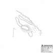
Four burnt mounds are situated in rough pasture on a SE-facing slope about 600m NE of Balnuick farmsteading. They are strung out over a distance of 200m on both sides of an un-named stream. All of the mounds are roughly circular or oval on plan, measuring up to 10m in diameter, but two probably overly smaller, earlier, mounds. A turf was removed from the surface of each mound, in all cases revealing a core comprising angular fragments of burnt stone and small fragments of charcoal contained within a matrix of loose black soil.
Visited by RCAHMS (JRS) 24 October 2006
NH92NE 34.01 NH 99083 26273
NH92NE 34.02 NH 99016 26371
NH92NE 34.03 NH 98999 26381
NH92NE 34.04 NH 98951 26427
Project (March 2007)
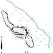
Detailed measured survey was undertaken in the Braes of Abernethy, Highland, by RCAHMS over the course of one week in March 2007. The archaeological and architectural monuments recorded were identified as worthy of further attention during a survey undertaken in 2006 (see Project Event 555817). The survey was designed to record a representative sample of the sites recorded in 2006, particularly those that were otherwise under-represented in then National Monuments Record of Scotland (now the National Record of the Historic Environment (NRHE)). The Pictish barrow cemetery at Pityoulish is situated outside the area of the original survey, but the opportunity to record it in detail for the first time was thought to be too good a chance to miss. Accordingly two parts of the site were recorded – the group of four ditched mounds at the NE end (Canmore ID 15389) and a solitary kerbed cairn 230m to the SW (Canmore ID 15413).
Information from HES Survey and Recording (JRS) 18 April 2018.
Measured Survey (7 March 2007)
RCAHMS surveyed the burnt mound at Finlarig on 7 March 2007 with plane-table at a scale of 1:100. The plan was redrawn in vector graphics software at a scale of 1:200.

