
Following the launch of trove.scot in February 2025 we are now planning the retiral of some of our webservices. Canmore will be switched off on 24th June 2025. Information about the closure can be found on the HES website: Retiral of HES web services | Historic Environment Scotland
Bowshank Tunnel


Railway Tunnel (19th Century)
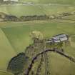
Site Name Bowshank Tunnel
Classification Railway Tunnel (19th Century)
Alternative Name(s) The Waverley Line; Edinburgh To Hawick Branch Railway
Canmore ID 283845
Site Number NT44SE 28.04
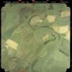
NGR NT 45339 41262
NGR Description From NT 45276 41338 to NT 45381 41171
Datum OSGB36 - NGR
Permalink http://canmore.org.uk/site/283845


- Council Scottish Borders, The
- Parish Stow
- Former Region Borders
- Former District Ettrick And Lauderdale
- Former County Midlothian
NT44SE 28.04 from 45276 41338 to 45381 41171
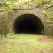
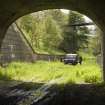
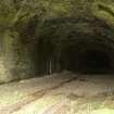
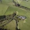
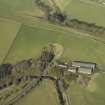
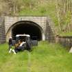
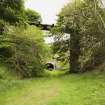
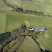
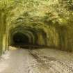
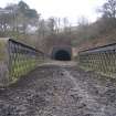
Railway Tunnel about 195m in length under 600m high promontory of land with Bowshank farmsteading on top.
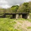
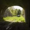
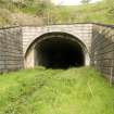
The Tunnel has a stone-faced portal at the N end only and is mainly brick lined. The N portal is in random rubble whilst the S entrance is of imitation rustication in shuttered concrete. There is evidence of repairs to the stone and brickwork at the N end, on the W side the strone quoins have been replaced with brick and the S portal has a secondary entrance in concrete providing evidence of major repair work or strengthening. The tunnel is numbered No.75.
There are several linesman's alcoves near the S entrance.
Photographed in 2007 as part of a survey of Waverley Line remains in advance of proposed rebuilding of the railway and to enhance and augment the existing holdings of the National Monuments Record Scotland.
Information from RCAHMS (DE), April 2007
Project (April 2009 - February 2015)
The Borders Railway Project proposals are to reinstate the Newcraighall to Tweedbank section of the former Waverley Line. The reinstated railway line will be approximately 48km long and the majority of the route will use the existing railway embankment.
Several field surveys, archaeological evaluations and standing building surveys were undertaken by CFA Archaeology from April 2009 until February 2015.
CFA Archaeology

