
Little Pinkerton


Settlement (Iron Age)
Site Name Little Pinkerton
Classification Settlement (Iron Age)
Canmore ID 283233
Site Number NT67NE 528
NGR NT 69556 76225
NGR Description Centre
Datum OSGB36 - NGR
Permalink http://canmore.org.uk/site/283233


- Council East Lothian
- Parish Dunbar
- Former Region Lothian
- Former District East Lothian
- Former County East Lothian
NT67NE 528 NT 69555 76223
Aerial Photographic Transcription (17 July 2019)
An interpretative transcription, or mapping, of information on oblique aerial photographs was produced on 17 July 2019.
Note (6 October 2022)
The location, classification and period of this site have been reviewed.
Aerial Photographic Interpretation (6 October 2022)
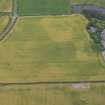
What may be the remains of an enclosed settlement of Iron Age date has been recorded as cropmarking on oblique photographs (RCAHMSAP 2005, 2015) in a field immediately E of Little Pinkerton. It measures about 76m from NW to SE by about 63m within a ditch 1-1.5m broad. There is an entrance gap on the E. A second gap in the SW corner is due to differential cropmark formation. The NW corner of the settlement extends into an area of deeper soil and so has not been recorded. Amorphous dark marks in the interior may reflect occupation remains, though alternatively may represent geological marks.
Information from HES Archaeological Survey (F. Vermeij) 6 October 2022
Note (10 June 2023)
The location, classification and period of this site have been reviewed and changed from ENCLOSED SETTLEMENT (IRON AGE)(POSSIBLE).

