
Pricing Change
New pricing for orders of material from this site will come into place shortly. Charges for supply of digital images, digitisation on demand, prints and licensing will be altered.
Upcoming Maintenance
Please be advised that this website will undergo scheduled maintenance on the following dates:
Thursday, 9 January: 11:00 AM - 3:00 PM
Thursday, 23 January: 11:00 AM - 3:00 PM
Thursday, 30 January: 11:00 AM - 3:00 PM
During these times, some functionality such as image purchasing may be temporarily unavailable. We apologise for any inconvenience this may cause.
Lynebeg


Cairnfield (Period Unassigned), Hut Circle (Prehistoric)
Site Name Lynebeg
Classification Cairnfield (Period Unassigned), Hut Circle (Prehistoric)
Canmore ID 282869
Site Number NJ01NE 51
NGR NJ 06165 19878
Datum OSGB36 - NGR
Permalink http://canmore.org.uk/site/282869


- Council Highland
- Parish Abernethy And Kincardine
- Former Region Highland
- Former District Badenoch And Strathspey
- Former County Inverness-shire
NJ01NE 51 NJ 06165 19878.
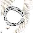
This hut-circle is situated on the top of a low rise on the W bank of an un-named stream 340m WNW of Lynebeg farmsteading (NJ01NE 49). It measures 8m in diameter within a heather-grown stony bank (up to 2.7m in thickness and 0.3m in height), which incorporates large boulders up to 0.5m in height. The entrance is on the E. About 70m S of the hut-circle there is a group of at least six heather-grown cairns measuring up to 3m in diameter.
Visited by RCAHMS (JRS) 22 August 2006.
Project (March 2007)
Detailed measured survey was undertaken in the Braes of Abernethy, Highland, by RCAHMS over the course of one week in March 2007. The archaeological and architectural monuments recorded were identified as worthy of further attention during a survey undertaken in 2006 (see Project Event 555817). The survey was designed to record a representative sample of the sites recorded in 2006, particularly those that were otherwise under-represented in then National Monuments Record of Scotland (now the National Record of the Historic Environment (NRHE)). The Pictish barrow cemetery at Pityoulish is situated outside the area of the original survey, but the opportunity to record it in detail for the first time was thought to be too good a chance to miss. Accordingly two parts of the site were recorded – the group of four ditched mounds at the NE end (Canmore ID 15389) and a solitary kerbed cairn 230m to the SW (Canmore ID 15413).
Information from HES Survey and Recording (JRS) 18 April 2018.
Measured Survey (9 March 2007)
RCAHMS surveyed the hut-circle at Lynebeg (NJ01NE 51) on 9 March 2007 with plane-table and self-reducing alidade at a scale of 1:250. The plan was redrawn in vector graphics software at a scale of 1:250.

