
Pricing Change
New pricing for orders of material from this site will come into place shortly. Charges for supply of digital images, digitisation on demand, prints and licensing will be altered.
Fae


Lime Kiln (19th Century)
Site Name Fae
Classification Lime Kiln (19th Century)
Canmore ID 282828
Site Number NJ01NE 27
NGR NJ 09277 17452
Datum OSGB36 - NGR
Permalink http://canmore.org.uk/site/282828


- Council Highland
- Parish Abernethy And Kincardine
- Former Region Highland
- Former District Badenoch And Strathspey
- Former County Inverness-shire
NJ01NE 27 NJ 09277 17452.
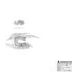
This limekiln has been set into the W face of a low rise 200m NNE of Fae (NJ01NE 47). Rectangular on plan, it measures 3.5m from ESE to WNW by 2m transversely within rubble walls that stand up to 2.6m in height on the WNW, where the top courses of the wall are corbelled At the foot of the WNW face there is a low arched opening. In places the inner face of the kiln has been vitrified. The kiln is first depicted on 2nd edition of the OS 6-inch map (Inverness-shire 1902, sheet LX).
Visited by RCAHMS (JRS) 9 August 2006.
Project (March 2007)
Detailed measured survey was undertaken in the Braes of Abernethy, Highland, by RCAHMS over the course of one week in March 2007. The archaeological and architectural monuments recorded were identified as worthy of further attention during a survey undertaken in 2006 (see Project Event 555817). The survey was designed to record a representative sample of the sites recorded in 2006, particularly those that were otherwise under-represented in then National Monuments Record of Scotland (now the National Record of the Historic Environment (NRHE)). The Pictish barrow cemetery at Pityoulish is situated outside the area of the original survey, but the opportunity to record it in detail for the first time was thought to be too good a chance to miss. Accordingly two parts of the site were recorded – the group of four ditched mounds at the NE end (Canmore ID 15389) and a solitary kerbed cairn 230m to the SW (Canmore ID 15413).
Information from HES Survey and Recording (JRS) 18 April 2018.
Measured Survey (5 March 2007)
RCAHMS surveyed Fae lime kiln on 5 March 2007 with plane-table at a scale of 1:100. The resultant ground plan and west elevation were redrawn in vector graphics software at a scale of 1:200.

