
Pricing Change
New pricing for orders of material from this site will come into place shortly. Charges for supply of digital images, digitisation on demand, prints and licensing will be altered.
Largs Harbour


Harbour (Period Unassigned)
Site Name Largs Harbour
Classification Harbour (Period Unassigned)
Canmore ID 281868
Site Number NS25NW 35
NGR NS 2003 5948
Datum OSGB36 - NGR
Permalink http://canmore.org.uk/site/281868


- Council North Ayrshire
- Parish Largs
- Former Region Strathclyde
- Former District Cunninghame
- Former County Ayrshire
NS25NW 35.00 2003 5948
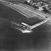
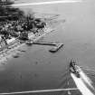
NS25NW 35.01 NS 20038 59487 Pier
NS25NW 35.02 NS c. 2004 5953 Beacon (on pier)
NS25NW 35.03 NS 20103 59491 Slipway ('Ferry Ramp')
Harbour [NAT] (at NS 2003 5948)
Ferry Vehicular Terminal [NAT] (at NS 20109 59517)
OS (GIS) AIB, June 2006.
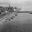
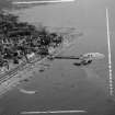
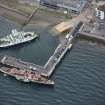
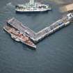
(Location cited as NS 201 595). Largs Harbour, built 1834. An L-plan masonry pier, the head of which is used by passenger steamers. To the N are the remains of a ramped rubble ferry pier.
J R Hume 1976.
(Location cited as NS 200 594). Largs had no harbour or pier before 1833, the lack of one being deplored in 1796, and the need being particularly felt when steamers from Glasgow began to ply. The work of 1833 was financed by a subscription for fifty shares, and the structure was described in 1847 as a small pier projecting 90yds [82.3m] with an end returning northwards for 47yds [43m]. It was thought that this returned end should be lengthened by a further 30yds [27.4m]. The pier gave a depth of from 5 to 15ft [1.5 to 4.6m] at low water. These figures agree well enough with what is found today, as the South Pier runs out approximately westwards for 100yds [91.5m] and the West Pier, evidently extended as was suggested in 1847, is now 77yds [70.4m] long. The construction, in squared masonry, is homogenous, but the extension is strengthened in places with massive timber uprights. The entrance, 60yds [54.9m] wide, is at the NW corner of the enclosed basin, the bulk of which, except near the entrance, dries out at low water. The N side, to landward of the entrance, is formed by a breakwater, vertical on its inner side and decreasing in thickness externally in three steps or, at its seaward end, in a flared slope. It consists for the most part of very large blocks, but more than one build can be seen and many traces of patching. Steps descend to the water on both sides of the S pier, in the angle of the basin, and inside the W pier; the basin is crossed obliquely by a ramp serving the ferry to the Great Cumbrae, and though this is now reconstructed in concrete it corresponds with a similar feature mapped in 1855-7.
In 1847, thirty-four herring-boats were owned in Largs and Fairlie togther. In the last decade of the 18th century, at the time of Largs Fair, which was held on the second Tuesday of June, the bay would be filled with boats from all quarters, some of them coming from as far away as Kintyre, and the potentialities of boat-traffic on this scale tends to throw doubt on the statement that 'no smuggling worth mentioning' went on in the parish in 1792.
A Graham 1984.
The 'South' and 'West' Piers that are noted by Graham are evidently the two elements of the pier NS25NW 35.01.
Information from RCAHMS (RJCM), 27 June 2006.

