Accessibility

Font Size

100% 150% 200%

Background Colour

Default Contrast
Close Reset

Pricing Change

New pricing for orders of material from this site will come into place shortly. Charges for supply of digital images, digitisation on demand, prints and licensing will be altered. 
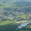
 

Conon Bridge

Village (Period Unassigned)

Site Name Conon Bridge

Classification Village (Period Unassigned)

Canmore ID 280194

Site Number NH55NW 185

NGR NH 543 554

NGR Description Centred NH 543 554

Datum OSGB36 - NGR

Permalink http://canmore.org.uk/site/280194

Ordnance Survey licence number AC0000807262. All rights reserved.
Canmore Disclaimer. © Bluesky International Limited 2025. Public Sector Viewing Terms

Toggle Aerial | View on large map

Digital Images

Aerial view of Conon Bridge, Easter Ross, looking SE.
Aerial view of Conon Bridge, Easter Ross, looking SE.An oblique aerial view of Conon Bridge, Black Isle, looking NW.General oblique aerial view looking towards Conon Bridge, Dingwall and the Cromarty Firth, taken from the SW.Aerial view of Conon Bridge, Black Isle, looking N.Aerial view of Maryburgh and Conon Bridge, Easter Ross, looking W.An oblique aerial view of Conon Bridge, Black Isle, looking N.Aerial view of Dingwall and Ben Wyvis, Easter Ross, looking NW.General oblique aerial view centred on Maryburgh, Garrie Island and the Conon Bridge under construction, looking to the NE.General oblique aerial view of Drynie Park looking towards Conon Bridge, taken from the S.An oblique aerial view of Conon Bridge, Black Isle, looking N.

Administrative Areas

  • Council Highland
  • Parish Urquhart And Logie Wester
  • Former Region Highland
  • Former District Ross And Cromarty
  • Former County Ross And Cromarty

Archaeology Notes

NH55NW 185 centred 543 554

References

MyCanmore Image Contributions


Contribute an Image

MyCanmore Text Contributions