
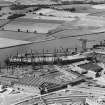
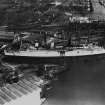
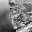
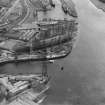
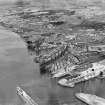
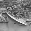
Clydebank, John Brown's Shipyard, Slipway


Slipway (19th Century) - (20th Century)
Site Name Clydebank, John Brown's Shipyard, Slipway
Classification Slipway (19th Century) - (20th Century)
Alternative Name(s) River Clyde
Canmore ID 278726
Site Number NS46NE 29.02
NGR NS 49682 69411
NGR Description NS c. 49682 69411 to NS c. 49711 69551
Datum OSGB36 - NGR
Permalink http://canmore.org.uk/site/278726


- Council West Dunbartonshire
- Parish Old Kilpatrick (Clydebank)
- Former Region Strathclyde
- Former District Clydebank
- Former County Dunbartonshire
NS46NE 29.02 c. 49682 69411 to c. 49711 69551
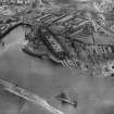
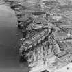
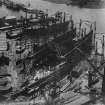
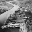
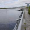
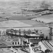
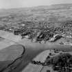
This slipway is of historical significance as the place of construction of numerous vessels of exceptional size, including all three 'Queens'. The mouth of the River Cart (into the S bank of the river, opposite the slipway) facilitated the launching of such craft.
Information from RCAHMS (RJCM), 9 February 2006.

