
Galashiels, Galafoot, Redbridge Viaduct, Bridge 104


Railway Viaduct (19th Century)
Site Name Galashiels, Galafoot, Redbridge Viaduct, Bridge 104
Classification Railway Viaduct (19th Century)
Alternative Name(s) The Waverley Line; Edinburgh To Hawick Branch Railway; Glaswiel Pot
Canmore ID 278439
Site Number NT53NW 71.01
NGR NT 51572 35251
NGR Description From NT 51544 35263 to NT 51606 35247
Datum OSGB36 - NGR
Permalink http://canmore.org.uk/site/278439


- Council Scottish Borders, The
- Parish Galashiels
- Former Region Borders
- Former District Ettrick And Lauderdale
- Former County Selkirkshire
NT53NW 71.01 From 51544 35263 to 51606 35247
E end falls in Melrose parish
Viaduct [NAT]
OS 1:2500 map, 1972.
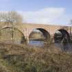
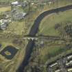
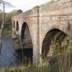
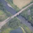
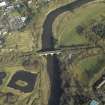
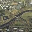
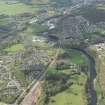
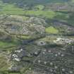
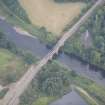
This viaduct formerly carried the Edinburgh - Carlisle main line of the North British Rly (the 'Waverley route') over the River Tweed to the E of Galashiels. The river here forms the boundary between the parishes of Galashiels (to the W) and Melrose (to the E).
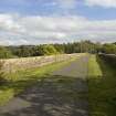
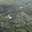
The location assigned to this record defines the centre of the span. The available map evidence suggests that it extends from NT c. 51552 35255 to NT c. 51603 35241. The viaduct is approached along embankments on both sides; the 1972 edition of the OS 1:10,000 map depicts a massive stone abutment to the W of the stream, while the viaduct also crosses a track to the E of the river.
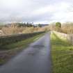
This portion of the Waverley route closed to regular passenger traffic on 6 January 1969.
Information from RCAHMS (RJCM), 31 January 2006.
G Daniels and L Dench 1980.
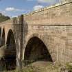
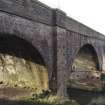
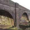
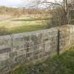
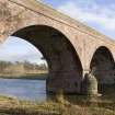
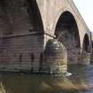
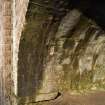
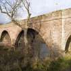
Red sandstone railway viaduct corssing the River Tweed at the Haughead Stream. Railway carried on a three main arches in rough sandstone with a smaller fourth over a track than formerly ran to a quarry on the S side of the river. A string course runs at trackbed level.
Two cutwaters are of regular sandstone blocks.
Project (April 2009 - February 2015)
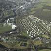
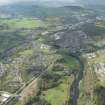
The Borders Railway Project proposals are to reinstate the Newcraighall to Tweedbank section of the former Waverley Line. The reinstated railway line will be approximately 48km long and the majority of the route will use the existing railway embankment.
Several field surveys, archaeological evaluations and standing building surveys were undertaken by CFA Archaeology from April 2009 until February 2015.
CFA Archaeology
Standing Building Recording (October 2011 - February 2012)
NT 4564 4454 Stow Station was built in the Victorian revivalist style and occupies roughly a Z-shaped plan with an assortment of 20th-century additions attached to its E and W-facing external elevations. The building is constructed of snecked sandstone and has ashlar dressings. The S-facing elevation incorporates a pedimented arch with pilasters. Historical photographs show that the arch housed the station clock. The interior of the building has been refurbished to suit the needs of 20th-century living, and there are no surviving period features associated with its former use as a ticket office and station masters house.
NT 4772 3858 The Torwoodlee gate piers are located on a minor trackway leading from the N to the Torwoodlee mansion house. The piers were hewn from single blocks of sandstone and are probably of mid-19th-century date.
NT 51572 35251 A Level 1 survey was carried out on the Category B Galafoot (Redbridge) Railway Viaduct located to the E of Galashiels. The viaduct was constructed in c1849 to cross the River Tweed for the North British Railway and formed the first part of the Waverley Railway Line from Edinburgh to Carlisle. Also known as the Tweed or Redbridge Viaduct, it is constructed of squared sandstone rubble with ashlar voussoirs on its segmental arches. The piers consist of rusticated sandstone with boat-shaped cutwaters on the upstream and downstream sides. The parapet is constructed of sandstone with ashlar copings. The viaduct is approached along embankments on both sides of the river. The 1972 OS map shows a massive stone abutment to the W of the stream, while the viaduct also crosses a track to the E of the river. The Waverley Railway, which closed to regular passenger traffic on 6 January 1969 and much of the route in Midlothian, currently forms part of a cycle track.
Archive: RCAHMS (intended). Report: Scottish Borders HER and RCAHMS
Funder: ERM Ltd on behalf of Transport Scotland
Stuart Mitchell, Graeme Carruthers, Mike Cressey - CFA Archaeology Ltd, 2013
(Source: DES)
Standing Building Recording (October 2011 - April 2012)
Situated to the east of Galashiels, Scottish Borders, this Grade B Listed
viaduct was constructed in c.1849 to cross the River Tweed for the North
British Railway and formed the first part of the line from Edinburgh to
Carlisle. Also known as the Tweed or Redbridge Viaduct, it is constructed of squared sandstone rubble with ashlar voussoirs on its segmental arches. The piers comprise rusticated sandstone with boat-shaped cutwaters on the upstream and down stream sides. The parapet is constructed of sandstone with ashlar copings.
The viaduct is approached along embankments on both sides of the river; the 1972 Ordnance Survey map depicts a massive stone abutment to the west of the stream, while the viaduct also crosses a track to the east of the river.
CFA Archaeology Ltd

