Lui Water
Lime Kiln (Post Medieval), Township (Post Medieval)
Site Name Lui Water
Classification Lime Kiln (Post Medieval), Township (Post Medieval)
Alternative Name(s) Mar Lodge Estate; Glen Lui; Derry Lodge; Croislish
Canmore ID 27759
Site Number NO09SE 3
NGR NO 0547 9245
Datum OSGB36 - NGR
Permalink http://canmore.org.uk/site/27759
- Council Aberdeenshire
- Parish Crathie And Braemar
- Former Region Grampian
- Former District Kincardine And Deeside
- Former County Aberdeenshire
Observation (1987)
NO09SE 3 055 924
Longhouse, 20m by 5m, partitioned with another, 16m by 5m, set at right angles. A three-sided enclosure beside the track. Stone clearance heaps on the 'greens'. Longhouse, 9m by 5m, with two abutting buildings with axes 14m and 20m forming L-plan, the larger with a square foundation at the free end. Slightly upslope on very much poorer ground, a multi-compartmented structure consisting of five square and rectangular enclosures in reversed L-shape.
J S Smith 1987.
Field Visit (23 June 1993)
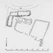
This township is situated above the floodplain of the Lui Water, below the modern track to Derry Lodge. It consists of two L-shaped farmsteads, standing on small terraces about 100m apart, with outlying buildings to the N and E, and two kilns and traces of rig cultivation to the S.
The E farmstead consists of a building (NO 0548 9245; MAR93 44) measuring 10.7m in length by 3.5m within walls 1m thick, with an extension on its W end 6.3m in length (MAR93 45). Built against the S wall of the extension, and forming a slightly obtuse angle with it, is another building measuring 9m in length and 2.8m in breadth within walls 0.9m in thickness (MAR93 46). This may have had opposed entrances, which would indicate that it was used as a barn. These buildings open onto a terrace on which stands an earlier building (overlain by MAR93 44), measuring 13.4m in length and 5.7m in breadth over walls reduced to stony banks 1.5m in thickness (MAR93 43). There are two enclosures on the terrace, one to the S of the earlier building, and probably associated with it, the other partly overlying this to the E.
The other L-shaped farmstead consists of a round-cornered building (NO 0537 9244; MAR93 51) measuring 8.3m N to S by 2.8m transversely within walls 0.8m in thickness, with a square-cornered building, measuring 11.3m in length and 3m in breadth within walls 0.9m in thickness, set at right angles to it and probably built over its NE corner (MAR93 50). The stump of a cruck survives in the NE corner of the larger building, and collapsed gables are suggested by the quantity of rubble at each end of it.
To the N of the latter group, and just below the modern track there is a single building measuring 6.3m in length and 2.3m in breadth within walls of faced-rubble embanked with turf (MAR93 52). To the N again, above the track on open moorland at NO 0541 9253 are two buildings, each having two compartments, set in an L-shape with an outshot built into the angle between them (MAR93 53-4). The two other outlying buildings (MAR93 41-2) are also on open moorland above the track, to the E of the main settlement, MAR93 41 being the furthest away at NO 0564 9248. These are both round-cornered structures with walls embanked with turf on their upslope sides. One (MAR93 41) has a stony bank partly enclosing it on the W and N, possibly the remains of an earlier construction.
To the S and W of the two main farmsteads there are patches of cleared ground, extending to about 2ha in all, on which traces of rig cultivation are visible. There are two kilns, one (NO 0541 9241; MAR93 49) set into a knoll in the middle of the cultivated ground, the other (NO 0542 9229; MAR93 48) situated down on the floodplain of the Lui Water. Both are substantial structures: MAR93 49 has an oval bowl measuring 2.7m in length and 2.2m in breadth, and the circular bowl of MAR93 48 has a diameter of 2.2m. Their size, and the absence of attached barns, suggests that they were for burning lime rather than for drying corn.
The surviving remains of this township indicate three phases of construction. The earliest is represented by one building, the grassed-over remains of MAR93 43; this was succeeded by a substantial round-cornered building (MAR93 44) which is similar in construction to most of the rest of the settlement, and indeed to most of the visible remains in the glen. A third phase appears to be represented by a building with square corners and gable ends (MAR93 50).
A map of the Forrest of Mar by John Farquharson, dated 1703 (National Library of Scotland), indicates three settlements in this area of Glen Lui; this township may be one of them. The township is not depicted by Roy (Roy 1747-55), but the 18th century estate rentals (Aberdeen University Library, MS 3175) list a farm in Glen Lui called Croislish for which there is no other candidate in Glen Lui.
(MAR93 41-6, 48-54)
Visited by RCAHMS (SDB) 23 June 1993.
Measured Survey (24 June 1993)
RCAHMS surveyed the farmstead at Croislish on 24 June 1993 at a scale of 1:250. The resultant plan was redrawn in ink and published at a scale of 1:500 (RCAHMS 1995b, Fig. 9).


