Creag Phadruig
Head Dyke (Post Medieval), Township (Post Medieval)
Site Name Creag Phadruig
Classification Head Dyke (Post Medieval), Township (Post Medieval)
Alternative Name(s) Glen Dee; Linn O' Dee; Mar Lodge Estate; Mar; Dubrach To East Dalvorar
Canmore ID 27749
Site Number NO08NW 3
NGR NO 046 893
NGR Description Centred NO 046 893
Datum OSGB36 - NGR
Permalink http://canmore.org.uk/site/27749
- Council Aberdeenshire
- Parish Crathie And Braemar
- Former Region Grampian
- Former District Kincardine And Deeside
- Former County Aberdeenshire
NO08NW 3 centred 046 893
See also:
NO08NW 15 NO 0486 8970 Building
See also NO08NW 1, NO08NW 4, NO08NW 7, NO08NW 9.
Above track, a longhouse, 12m by 5m, with circular kiln at west end. Longhouse, 28m by 5m, partitioned into three, together with a bowed outbuilding at west end. Mature pines growing through foundations. Below track on terrace, area enclosed by dyke, and longhouse 15m by 5m, circular stone-lined pit 3.5m in diameter, longhouse 15m by 5m. Stone clearance heaps, walls and small enclosed plots. Rig and furrow present. On the apex of the fan, both linear and round clearance heaps.
Head-dyke cut-out to west by River Dee.
J S Smith 1987
Scheduled with NO08NW 1, NO08NW 4, NO08NW 7, NO08NW 9 as 'Mar, townships, field systems, stills and kilns, Dubrach to E[ast] Dalvorar'.
Information from Historic Scotland, scheduling document dated 30 March 2009.
Observation (1987)
NO08NW 3 centred 046 893
Above track, a longhouse, 12m by 5m, with circular kiln at west end. Longhouse, 28m by 5m, partitioned into three, together with a bowed outbuilding at west end. Mature pines growing through foundations. Below track on terrace, area enclosed by dyke, and longhouse 15m by 5m, circular stone-lined pit 3.5m in diameter, longhouse 15m by 5m. Stone clearance heaps, walls and small enclosed plots. Rig and furrow present. On the apex of the fan, both linear and round clearance heaps.
Head-dyke cut-out to west by River Dee.
J S Smith 1987
Field Visit (24 June 1993)
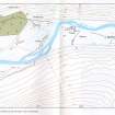
Three subrectangular buildings and a kiln are situated on the N side of haughland to the N of the River Dee below Creag Phadruig. Two of the buildings lie towards the N edge of the haughland, with one building and the kiln on a slight terrace on the valley side, immediately to the N of the modern track. The buildings (MAR93 270-2) measure up to 11.9m by 3.1m within faced-rubble footings up to 1m in thickness and 1m in height; the largest building (MAR93 270) has substantial outshots on both ends, extending for 4.2m and 11.7m. One building (MAR93 270) is depicted as unroofed on the 1st edition of the OS 6-inch map (Aberdeenshire 1867, Sheet xcvii), with a second, unroofed, building to the W, where there is now a small quarry. One of the buildings (MAR93 271) on the haughland is partially overlain by a fold. The kiln-bowl (MAR93 269) measures 1.9m across and 1m deep, and there is a barn extending for 6.3m to the ENE.
A ruinous drystone wall encloses the haughland to the S of the buildings and may form part of a wider enclosure associated with a post-clearance sheep farm (Watson and Allan 1990) (see also NO08NW 1). A hut (MAR93 273) is attached to the wall close to the N bank of the River Dee. There are patches of rig on the haughland, generally coincidental with areas of grass with scatters of cleared stone, at the edges of the cultivated ground.
Roy (Roy 1747-55) shows at least four buildings at this location with cultivated ground along the N side of the Dee.
(MAR93 269-73)
Visited by RCAHMS (DCC) 24 June 1993
Note (22 March 1999)
In addition to the two unroofed buildings, a head-dyke, which encloses two areas, one to the N and the other to the S of the track, is depicted on the 1st edition of the OS 6-inch map (Aberdeenshire 1869, sheet xcvii). Four unroofed buildings and the head-dyke to the S of the track are shown on the current edition of the OS 1:10000 map (1971).
Information from RCAHMS (SAH) 22 March 1999
Conservation (1999)
NO 047 894; NO08NW 7 A programme of restoration and conservation was undertaken at two post-medieval sites on the Mar Lodge Estate. The township of Craig Phadruig on the N side of the Dee (NO 047 894) and the township of Tonnagaoithe a little way upstream (NO08NW 7). The conservation works were to repair recent damage and consolidate the structures.
NO 045 896 A well-hidden, well-preserved still site was discovered on the Allt Creag Phadruig.
NO 048 895 Located on the N side of the track, a stone-revetted hollow forms a well.
Full report deposited with the NMRS and Aberdeen SMR.
Sponsor: National Trust for Scotland
S Bain 1999.


