
Pricing Change
New pricing for orders of material from this site will come into place shortly. Charges for supply of digital images, digitisation on demand, prints and licensing will be altered.
Castlelaw And Dreghorn Training Area


Firing Range (20th Century), Firing Range (First World War), Military Training Site (First World War), Military Training Site (20th Century), Trench (First World War), Trench(S) (20th Century)
Site Name Castlelaw And Dreghorn Training Area
Classification Firing Range (20th Century), Firing Range (First World War), Military Training Site (First World War), Military Training Site (20th Century), Trench (First World War), Trench(S) (20th Century)
Canmore ID 277108
Site Number NT26SW 135
NGR NT 228 642
NGR Description NT 228 642 (centred)
Datum OSGB36 - NGR
Permalink http://canmore.org.uk/site/277108


- Council Midlothian
- Parish Glencorse
- Former Region Lothian
- Former District Midlothian
- Former County Midlothian
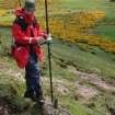
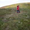
Field Visit (23 June 2005)
NT26SW 135 228 642 (centred)
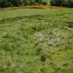
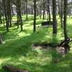
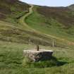
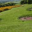
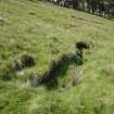
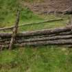
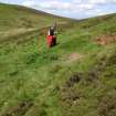
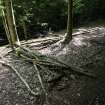
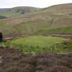
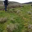
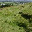
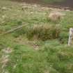
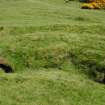
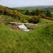
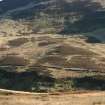
The Castlelaw and Dreghorn Training Area (CDTA) is situated at the NE end of the Pentland Hills, its southern end on the OS 1:10,000 mapsheet NT26SW and northern end on NT26NW (see NT26NW 464). The southern part comprises Castlelaw Hill (488m OD), the southern flank of Woodhouselee Hill, and an area on the lower slope made up of a patchwork of rough pasture, arable fields and small areas of woodland running down to Glencorse Burn and Reservoir. The area has been used for military training since about the First World War, and an RAF vertical aerial photograph taken in 1947 (CPE/Scot/UK281, 5322) shows the Castlelaw Rifle Ranges (NT26SW 65) before they were rebuilt in the early 1980s. An extensive system of practice-trenches can also be seen, mainly on Castle Knowe (NT26SW 117), and extending in small patches of pasture and woodland across the lower slopes of both Castlelaw Hill and Woodhouselee Hill. Other features of military origin include a number of platforms, stances and structures (CDTA05 17, 105, 67), and numerous shell- and mortar-craters. Hundreds of locations are visible where the turf has been removed to create shallow fox-holes or bivouacs. These can be found throughout the training area, but they are most common in woodland on the lower ground, some being dug as recently as within the past year.
(CDTA05 17, 105, 67)
Visited by RCAHMS (AGCH) 23 June 2005
Project (May 2005 - November 2005)
This project was designed to map in detail the archaeological landscape within a military training area that has been in use for about 90 years. The area, which is situated close to the northeast end of the Pentland Hills, immediately south of Edinburgh, comprises about 8km² of largely rough hill-pasture. Several prehistoric monuments were previously recorded within the area, but new discoveries mainly comprise structures that relate to the use of the area as a sheep-walk in the 19th and 20th centuries or reflect the more recent employment of the area for military training. The earlier sites include a variety of huts, folds and enclosures, but of particular interest is the system of water meadows identified on the south-east flank of Capelaw Hill and the catch-drains on the north-west flank of the hill. The former were designed to improve the quality of the pasture, while the latter were dug to supplement the supply of water to Bonaly Reservoir, one of the sources that provided drinking water to Edinburgh in the 18thand19th centuries. The later military sites include systems of practice trench, disused small-arms and grenade-ranges, and hundreds of fox-holes.
DES 2005, 150
The results of this project are available as a report produced in 2008: Collection Item WP00004452 (WP00004452.pdf (rcahms.gov.uk)) The baseline survey included the mapping of 157 monuments, the identification of 275 structures and the collection of 258 digital photographs.
Project (March 2013 - September 2013)
A project to characterise the quantity and quality of the Scottish resource of known surviving remains of the First World War. Carried out in partnership between Historic Scotland and RCAHMS.

