
Pricing Change
New pricing for orders of material from this site will come into place shortly. Charges for supply of digital images, digitisation on demand, prints and licensing will be altered.
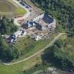
Skye, Knock House, Steadings


Farmstead (18th Century)
Site Name Skye, Knock House, Steadings
Classification Farmstead (18th Century)
Canmore ID 275889
Site Number NG60NE 20.01
NGR NG 67082 09019
Datum OSGB36 - NGR
Permalink http://canmore.org.uk/site/275889


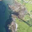
- Council Highland
- Parish Sleat
- Former Region Highland
- Former District Skye And Lochalsh
- Former County Inverness-shire
Knock Farmhouse, 18th century Former tacksman's house, with lower flanking offices as crosswise wings, shown on Mathew Stobie's map of 1763 alongside formal gardens. On the first floor, late 18th/early 19th century panelling, the east room with some rare painted panels. Alterations by James Gillespie Graham, 1802. Large court of steadings on riverbank, c.1800, undergoing conversion by Simpson & Brown Architects to a whisky distillery and visitor centre - Stal Thorabhaig (see p.211 ). Former mill (now roofless) below.
Taken from "Western Seaboard: An Illustrated Architectural Guide", by Mary Miers, 2008. Published by the Rutland Press http://www.rias.org.uk


