Pricing Change
New pricing for orders of material from this site will come into place shortly. Charges for supply of digital images, digitisation on demand, prints and licensing will be altered.
Tulloch Field, Enochdhu
Hut Circle(S) (Bronze Age)
Site Name Tulloch Field, Enochdhu
Classification Hut Circle(S) (Bronze Age)
Canmore ID 27582
Site Number NO06SE 20
NGR NO 054 637
Datum OSGB36 - NGR
Permalink http://canmore.org.uk/site/27582
- Council Perth And Kinross
- Parish Moulin
- Former Region Tayside
- Former District Perth And Kinross
- Former County Perthshire
Field Visit (23 October 1973)
NO06SE 20 0545 6370.
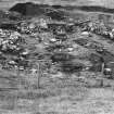
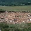
At NO 0545 6370 excavated into a steep SW-facing slope are five sub-circular platforms (A - E) which may be hut stances but are rather different to the general style of hut circle in this locality. One (A) is reminiscent of the unenclosed platform houses of the border counties. With the exception of 'B' (which is a simple platform), each has the remains of a substantial stone wall around the forward half of the platform, with a considerable back scarp.
'A' measures c. 9.5m in diameter, edged in the NW by a wall spread to 3.0m. The entrance may have been in the mutilated W arc.
'B' is a platform 10.0m in diameter with a slight stony build-up around much of the perimeter. A slight dip in the S may indicate the entrance. 'C', roughly circular, is c. 8.2m in diameter.
'D', roughly oval, is 9.5m ESE-WNW by 8.0m, adjacent to 'C' but at a lower level, with no evident of inter-communication.
'E' is 14.5m NE-SW by 11.0m within a wall spread to 3.0m. The entrance is in the SW.
Another platform (F) occurs in a plantation to the NNW. It measures about 11.5m in diameter, is open to the SW and defined by a back scarp elsewhere. To the W of this on a knoll is a normal circular stone-walled hut (G), measuring 13.5m in diameter between the centres of a strong wall spread to 4.0m, showing several boulders in it. The entrance is in the NNE.
Their off-circular plan, well-defined condition, and position on the SW fringe of a large area of depop cultivation suggests that they could be due to recent activities, but an excavation of the entrance to 'E' by Mrs Stewart in 1972 produced charcoal and undecorated sherds of coarse pottery datable to the later half of the 1st millennium B C. (M E C Stewart) and the probability is that this is an Iron Age settlement. There are some stone clearance heaps amongst the heaps and lynchets of the late cultivation, which could be contemporary with the settlement, especially to the W of hut 'G'.
Surveyed at 1:2500.
Visited by OS (AA) 23 October 1973
Excavation (1976 - 1980)
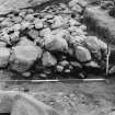
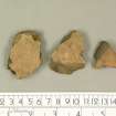
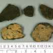
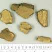
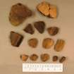
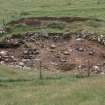
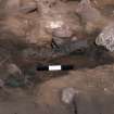
Further excavations were carried out within and around 'E' in 1976-7. Its wall was shown to be about 2.0 m wide and composed of rounded boulders of varying sizes. No evidence of any internal structure was noted, though dark soil containing some large pieces of charcoal and carbonised seeds was located. Numerous sherds of undecorated, coarse, gritty pottery were found. The pottery and samples of soil and charcoal are in Dundee Museum.
L M Thoms 1976, 1977
In July 1980 the E half of platform 'A' was excavated, producing structure post holes and similar prehistoric material to that taken from platform 'E'. (Carbon-14 dates from 'E' suggest a Late Bronze Age occupation.) Excavation is sue to continue in 1981; a report is pending. L M Thoms, Dundee Museum
Field Visit (3 September 1980)
This unenclosed platform settlement at about 270m OD is generally as described.
Hut 'G' is somewhat isolated from, and of differing construction and setting to platforms A - F; it may not be contemporary although in appearance it is likely to be prehistoric. The recent excavation (4) of platform 'A' remains open, but the outline of 'E' has been largely destroyed by the previous excavations (1, 2). The interior of 'F' appears to be only superficially damaged by surrounding forestry. It was not possible to isolate any prehistoric field system from the extensive area of later land usage and occupation that bounds the settlement.
Surveyed at 1:2500.
Visited by OS (JRL) 3 September 1980
Field Visit (8 July 1988)
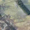
A group of at least six hut-circles and circular platforms are located at the upper edge and the foot of an old river terrace 330m NNW of Tulloch cottage. The platforms are described from SE to NW.
1. NO 0547 6368 (OS 'C') This structure is terraced into the farm track immediately to the E. It measures 8m in diameter and is defined by a scarp on the N and E and a turf-covered bank (up to 1.8m thick and 0.5m high) on the SE. Slight traces of the bank survive on the SW but there is a wide gap on the W where the apparently natural slope drops down into the back of platform (2); there is little evidence of an entrance.
2. NO 0546 6369 (OS 'D') Situated immediately NW of, and below (1), there are the remains of a hut-circle which measures about 8.8m in internal diameter and is defined by a scarp on the N and E, and a bank (2.6m thick and 0.5m high) from the SE to the SW. As with (1) there is a wide gap, presumably for an entrance, on the W.
3. NO 0545 6373 (OS 'B') This hut-circle is situated at the upper edge of the terrace 32m N of (2), and measures 9.3m in internal diameter, it is defined by a back-scarp (0.5m high) on the NE and a bank (2.2m thick and 0.4m high) on the SE. Elsewhere there is only a low rim marking the front of the platform and there is no indication of the entrance.
4. NO 0544 6370 (OS 'E') Situated at the foot of the terrace and about 20m SW of (3), there is a hut-circle which was subject to a small-scale excavation by Dr M E C Stewart in 1971 or 1972 and a larger-scale examination by Miss L M Thoms of Dundee Museum between 1976 and 1979 Stewart's excavation was limited to the entrance area but it produced charcoal and sherds of undecorated pottery. Thom's excavation examined most of the interior of the platform and uncovered the top of much of the surrounding wall; it was roughly oval on plan, measuring about 14.5m NE-SW by about 10m transversely within a boulder wall spread up to 3.6m in thickness. There was an entrance (about 2m wide) on the SSW and within the bank there were two arcs of post-holes set in a bedding trench. Further post-holes on the diameter of the bedding trenches may be contemporary, as may be other features within the central area of the platform. The diameter of the inferred post-ring is in the region of 6.8m and C-14 dates for charcoal (Betula sp) from the SW and NE arcs are 3040 +/- 45 b.p. and 3015 +/- 50 b.p. respectively. Finds, apart from those of charcoal were limited to sherds of coarse pottery a number of which belonged to a bucket-shaped vessel about 250mm high and 175mm in diameter at the rim (now in Dundee Art Gallery and Museum).
5. NO 0543 6373 (OS 'A') Situated at the foot of the terrace about 25m NW of (4), there is a further hut-circle which was excavated by Thoms between 1980 and 1983. Excavation revealed a platform measuring about 12m in diameter within a low rubble bank up to 4m in thickness (on the W). Within the bank there were two rings of post-holes; an inner of five measuring about 3.5m in diameter and an outer of ten measuring about 7.6m in diameter. The entrance appears to have been on the S side and was defined by two small posts (0.8m apart) set 1.5m outside the line of the outer post-ring. Further features include other post-holes, larger pits, lengths of possible post-hole trenches and two elongated pits very similar in character to the two arcs of bedding-trench in hut-circle (4). A C-14 date from one of the larger pits in (5) (possibly a hearth-pit), derived from a composite sample of birch (Betula sp) and oak (Quircus sp), was 2275 +/- 60 b.p. The probable re-use of one of the post-holes on the N side of the outer ring and apparently 'stray' post-holes and pits within the interior may indicate that the platform had more than one phase of use. Finds from (5) included numerous sherds of coarse pottery, a fragment of a possible quern stone, fragments of quartz which may have been utilised as scrapers, a small piece of flint and a small fragment of bronze which may have been part of a pin (now in Dundee Museum and Art Gallery).
6. NO 0539 6380 (OS 'F') Situated within the plantation to the NW, but on the face of the same SW-facing terrace, there is a platform measuring 10.5m in diameter. Its back-scarp (0.7m high) is partly faced with large boulders and on the E there is a segment of bank (2.7m thick and 0.6m high). On the S and SW however, the front of the platform is marked only by a break in slope.
7. NO 0530 6381 (OS 'G') This possible hut-circle is situated on a low knoll in pasture 140m to the NW of the plantation. It measures 10.5m in diameter within a turf-covered bank (2.3-3.2m thick and 0.5m high) and possible outer facing-stones are visible on the NW. Several large boulders lie on the bank on the E and SE, and on the NNE there is a wide gap in the bank, opening on to a ramp which descends to the foot of the knoll.
Visited by RCAHMS (JRS) 8 July 1988.
L M Thoms 1976, 1977, 1978, 1979, 1980, 1981, 1982, 1983; RCAHMS 1990
Measured Survey (August 2013)
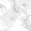
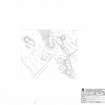
A group of hut-circles at Enochdhu, Strathardle, was first excavated in the early 1970s by Dr Margaret Stewart and then later by Liz Thoms, at that time with the City of Dundee Museum Service. A detailed survey was undertaken in August 2013, in part to clarify and enhance the existing Canmore record of the site but also to provide an illustration for a paper on the excavations.
Visited by RCAHMS (JRS, GFG, IP, AM) August 2013.


