
Barnhills


Farmstead (Post Medieval), Threshing Machine (Post Medieval)
Site Name Barnhills
Classification Farmstead (Post Medieval), Threshing Machine (Post Medieval)
Canmore ID 274531
Site Number NW97SE 35
NGR NW 99020 71580
Datum OSGB36 - NGR
Permalink http://canmore.org.uk/site/274531


- Council Dumfries And Galloway
- Parish Kirkcolm
- Former Region Dumfries And Galloway
- Former District Wigtown
- Former County Wigtownshire
NW97SE 35 9902 7158
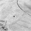
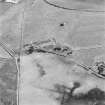
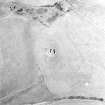
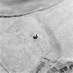
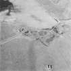
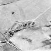
This farmstead, which is depicted on the 1st edition of the OS 6-inch map (Wigtonshire 1849, sheet 4) as five roofed buildings and six enclosures, has been recorded on oblique aerial photography (RCAHMSAP 1999) as comprising two unroofed buildings and two enclosures.
Information from RCAHMS (KMM) 16 August 2005
Note (4 March 2022)
The location, classification and period of this site have been reviewed and changed from FARMSTEAD (PERIOD UNASSIGNED), THRESHING MACHINE (POST MEDIEVAL).

