
Following the launch of trove.scot in February 2025 we are now planning the retiral of some of our webservices. Canmore will be switched off on 24th June 2025. Information about the closure can be found on the HES website: Retiral of HES web services | Historic Environment Scotland
Balnabroich


Building (Medieval) - (Post Medieval), Pitcarmick Building(S) (Early Medieval)
Site Name Balnabroich
Classification Building (Medieval) - (Post Medieval), Pitcarmick Building(S) (Early Medieval)
Canmore ID 27296
Site Number NO05NE 45
NGR NO 09912 57573
Datum OSGB36 - NGR
Permalink http://canmore.org.uk/site/27296


- Council Perth And Kinross
- Parish Kirkmichael (Perth And Kinross)
- Former Region Tayside
- Former District Perth And Kinross
- Former County Perthshire
Field Visit (October 1987)
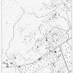
NO05NE 45 0995 5758.
At the NW end of the group of hut-circles NO 15 NW 14 there are two Pitcarmick-type buildings; a subrectangular building lies on the NW side of the burn to the N.
1. NO 0991 5757 The principal Pitcarmick-type building is crossed by the track 40m E of a stone dyke; it measures 30m in length overall by a maximum of 8.5m in breadth. The SE end narrows to 4.5m in breadth which may represent an outshot with a separate entrance. The whole of the interior has been levelled into the slope, and the SE end of the main building is more deeply hollowed than the rest. Immediately upslope a subsidiary scarp, which runs the length of the NE side, cuts through an earlier building which measures 20m in overall length. The interior of the earlier building has been levelled into the slope, and there are traces of a drainage ditch along the NE side.
2. NO 0998 5753 The second Pitcarmick-type building, its walls reduced to low banks, measures 15m in length overall by 6m in breadth, and there is a shallow depression at the SE end of the interior. The entrance is midway along the SW side. Immediately to the S there is what is either another building or a small annexe.
3. NO 0995 5763 The subrectangular building to the N measures about 12m by 5m over walls about 0.3m high and there is a drainage ditch along its NW side; the entrance is on the SE. The NW wall extends SW beyond the end of the building, turns towards the SE and peters out.
Visited by RCAHMS (SPH) October 1987
RCAHMS 1990.
Measured Survey (1987)
RCAHMS surveyed the hut circles, field system and Pitcarmick-type buildings at Balnabroich in 1987 at a scale of 1:2500. The resultant plan was redrawn in ink and published at a scale of 1:5000 (RCAHMS 1990, Fig. 108A).
Measured Survey (1987)
RCAHMS surveyed the principal Pitcarmick-type house at Balnabroich (NO 0991 5757) in 1987 at a scale of 1:250 with self-reducing alidade and plane-table. The site plan was redrawn in ink and published at a scale of 1:500 (RCAHMS 1990, Fig. 227.1A).
Measured Survey (1987)
RCAHMS surveyed a second Pitcarmick-type house at Balnabroich (NO 0998 5753) in 1987 at a scale of 1:250 with self-reducing alidade and plane-table. The site plan was redrawn in ink and published at a scale of 1:500 (RCAHMS 1990, Fig. 227.1B).

