
Pricing Change
New pricing for orders of material from this site will come into place shortly. Charges for supply of digital images, digitisation on demand, prints and licensing will be altered.
Cape Wrath Range


Bombing Range (20th Century), Firing Range (20th Century)
Site Name Cape Wrath Range
Classification Bombing Range (20th Century), Firing Range (20th Century)
Canmore ID 272933
Site Number NC26NE 2
NGR NC 2967 6857
Datum OSGB36 - NGR
Permalink http://canmore.org.uk/site/272933


- Council Highland
- Parish Durness
- Former Region Highland
- Former District Sutherland
- Former County Sutherland
Field Visit (2008)
NC26NE 2 2967 6857
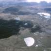
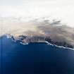
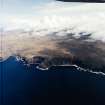
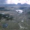
The Cape Wrath Training Centre (CWTC), which covers some 59 sq km of peaty moorland in NW Sutherland, was established about 1933 as a naval gunnery and bombing range, but since 2005 it has served as a multi-services Training Centre for sea-based, airborne and terrestrial exercises. The use of the area primarily as a remote gunnery and bombing range has meant that there has been very little requirement for permanent military structures within the range.
The Ministry of Defence own the former shepherd’s house and barn at Inshore (NC36NW 12), the former hunting lodge at Kearvaig Bay (NC27SE 13), and the early-19th century store house at Clais Charnach (NC27SE 4). All four buildings are maintained for use by the military during exercises and at other times. In addition to these buildings, there are three sentry posts, two of which, at Kearvaig River (NC27SE 44) and Achiemore (NC36NE 102), prevent public access to the main danger area during exercises. The third sentry post, at Allt Luachrach (NC27SE 45), was established but never, according to the current range wardens, actually used.
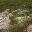
Four small stone-built shelters, one on the summit of Cnoc A’ Ghiubhais (NC27SE 11), two on the NE shoulder of Fashven (NC36NW 13 & 14), and one on the E shoulder of Sgribhis-bheinn (NC37SE 5), may have been built by military personnel reporting on target practice. Their respective positions on high, very exposed locations suggest that they are not shepherds’ or walkers’ shelters, and all of them overlook major target areas.
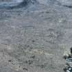
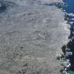
There is extensive evidence, in the form of shell- and bomb-craters, within the CWTC for its use as a target area within the bombing and offshore gunnery range. Targets have taken a number of forms over the years, including old oil drums and scrap vehicles; other types of target have either been completely destroyed or removed.
Immediately before 2005, there appears to have been two main target areas. One of these was the terrace at the foot of the NE flank of Sgribhis-bheinn (NC37SW 29), the other (NC37SE 15) in and around the fort at Eilean nan Caorach (NC37SE 1). Both targets comprised clusters of old vehicles, now all burnt-out rusting wrecks. Since 2005, redundant armoured personnel carriers and steel transport containers have been used as targets on Sgribhis-bheinn and a similar use has been put to APCs and containers at several other locations in the range, including at Cnoc nan Tri-Mile (NC27SE 43), Kearvaig River (NC27SE 49), Allt an Fhasaraidh Mhòir (NC27SE 50) and Inshore (NC36NW 22). In recent times, the fort on Eilean nan Caorach appears not to have been used as a target.
Recent terrestrial exercises within the Training Centre have left their mark in a number of ways. A small number of fox-holes and shallow slit-trenches are evident, particularly in the valley of the Kervaig River, south of the bridge NC27SE 15, but the locations of these were not recorded by RCAHMS in 2008. In moorland at Allt na Luachrach (CWTC08 115) and on Cnoc nan Tri-Mile (CWTC08 414) there are the remains of what were probably temporary small-arms targets or firing positions. At both locations a structure comprising sand bags and timber has been demolished, with the contents of the sand bags emptied out and the timber burnt on an adjacent fire.
For about the first thirty years of its existence the control of the bombing range was effectively carried out from offshore. In the early 1960s, however, a new range control facility was established at the former ROTOR radar station at Faraid Head (NC37SE 4) on the E side of the Kyle of Durness.
Visited by RCAHMS (JRS, JH) 12 August 2008.

