
Pricing Change
New pricing for orders of material from this site will come into place shortly. Charges for supply of digital images, digitisation on demand, prints and licensing will be altered.
Achiemore


Farmstead (Period Unassigned), Field Boundary(S) (Period Unassigned), Rig And Furrow (Medieval) - (Post Medieval)
Site Name Achiemore
Classification Farmstead (Period Unassigned), Field Boundary(S) (Period Unassigned), Rig And Furrow (Medieval) - (Post Medieval)
Canmore ID 272928
Site Number NC36NE 97
NGR NC 3606 6799
Datum OSGB36 - NGR
Permalink http://canmore.org.uk/site/272928


- Council Highland
- Parish Durness
- Former Region Highland
- Former District Sutherland
- Former County Sutherland
NC36NE 97 3606 6799
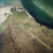
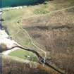
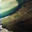
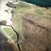
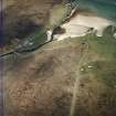
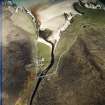
This farmsteading, comprising two buildings and a rectilinear enclosure, has been recorded on oblique aerial photography (RCAHMSAP 2004) lying within the remains of a system of field banks and rig on the W shore of the Kyle of Durness. The farmstead is depicted on the 1st edition of the OS 6-inch map (Sutherland 1878, Sheet V) as three roofed buildings and a rectilinear enclosure. The rig and field banks lie between the shore and the line of the modern road.
Information from RCAHMS (KMM) 21 April 2005

