
Achiemore


Farmstead (Period Unassigned), Field Boundary(S) (Period Unassigned), Rig And Furrow (Medieval) - (Post Medieval)
Site Name Achiemore
Classification Farmstead (Period Unassigned), Field Boundary(S) (Period Unassigned), Rig And Furrow (Medieval) - (Post Medieval)
Canmore ID 272928
Site Number NC36NE 97
NGR NC 3606 6799
Datum OSGB36 - NGR
Permalink http://canmore.org.uk/site/272928


- Council Highland
- Parish Durness
- Former Region Highland
- Former District Sutherland
- Former County Sutherland
NC36NE 97 3606 6799
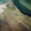
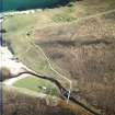
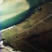
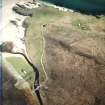
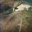
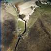
This farmsteading, comprising two buildings and a rectilinear enclosure, has been recorded on oblique aerial photography (RCAHMSAP 2004) lying within the remains of a system of field banks and rig on the W shore of the Kyle of Durness. The farmstead is depicted on the 1st edition of the OS 6-inch map (Sutherland 1878, Sheet V) as three roofed buildings and a rectilinear enclosure. The rig and field banks lie between the shore and the line of the modern road.
Information from RCAHMS (KMM) 21 April 2005

