
Balnabroich


Standing Stone(S) (Prehistoric)
Site Name Balnabroich
Classification Standing Stone(S) (Prehistoric)
Canmore ID 27267
Site Number NO05NE 2
NGR NO 0918 5658
NGR Description NO 0918 5658 and NO 0917 5675
Datum OSGB36 - NGR
Permalink http://canmore.org.uk/site/27267


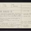
- Council Perth And Kinross
- Parish Kirkmichael (Perth And Kinross)
- Former Region Tayside
- Former District Perth And Kinross
- Former County Perthshire
NO05NE 2 0918 5658 to 0917 5675.
(NO 0916 5658) Standing Stones (NR)
(NO 0916 5674) Standing Stone (NR)
OS 6" map, Perthshire, 2nd ed. (1900)
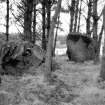
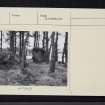
Two stones stand on a natural mound. The stone on the N is a rough mass of whinstone 4'2" high with a basal girth of 10'9". Close in front of its E edge is a small, flat, apparently earth-fast block, nearly flush with the ground.
F R Coles 1908
Another stone, 10'4" away, has fallen outwards so that its S edge is now only 2'6" above the ground. It has a basal girth of over 15'. Due N of these two stones is a third, 5'8" high.
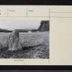
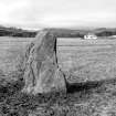
Three standing stones, 'A', 'B', and 'C'. 'A', in an open field. According to Mr Murray (J Murray, Balnabroich, Kirkmichael) immediately S of this stone is a large flat slab about 1' below ground level which he has caught several times with his plough but is too heavy to move. Stones 'B' and 'C' stand on top of a narrow glacial ridge, a prominent, though restricted, position which indicates that the stones have never been part of a stone circle or cairn. The "small, flat, apparently earth-fast block" is part of the packing around the base of stone 'B'. Visited by OS (ISS) 1 November 1973
Field Visit (October 1986)
NO 0918 5658
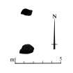
Situated on a slight rise at the NE end of a plantation and 50m NE of the steading at Balnabroich, there is a pair of standing stones. The N stone (A) is 1.35m high, rises with straight sides to a flat top, and leans slightly to the S; the S stone (B) is irregular in shape and leans so far to the S that it is not possible to estimate its original height. (for a third stone see NO05NE 79).
Visited by RCAHMS (JBS) October 1986.
RCAHMS 1990
Measured Survey (7 October 1986)
RCAHMS surveyed the standing stones at Balnabroich by alidade and plane-table on 7 October 1986 at a scale of 1:125. The resultant plan was redrawn in ink and published at a scale of 1:250 (RCAHMS 1990, Fig. 60).

