
Lewis, South Galson


Farmstead (Period Unassigned), Lazy Beds (Post Medieval), Township (Period Unassigned)
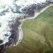
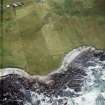
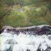
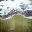
Site Name Lewis, South Galson
Classification Farmstead (Period Unassigned), Lazy Beds (Post Medieval), Township (Period Unassigned)
Alternative Name(s) Gabhsunn O'dhear
Canmore ID 272535
Site Number NB45NW 66
NGR NB 4348 5868
NGR Description Centred on 4348 5868
Datum OSGB36 - NGR
Permalink http://canmore.org.uk/site/272535


- Council Western Isles
- Parish Barvas
- Former Region Western Isles Islands Area
- Former District Western Isles
- Former County Ross And Cromarty
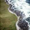
NB45NW 66 Centred on 4348 5868
The crofting township and field system of South Galston is depicted on the current edition of the OS 1:10000 map (1974), but is not shown on the 1st edition of the OS 6-inch map (Island of Lewis, Ross-shire 1853, sheet 2) which shows only a cluster of five roofed buildings set around a courtyard, annotated as Galston Farm House, and a system of fields. It overlies the earlier township of Ath Cheapach (NB45NW 59).
Information from RCAHMS (KMM) 20 May 2005

